|
search place name
|
||
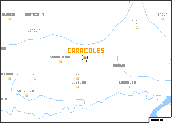
Caracoles (Pando, Bolivia)Caracoles is a town in the Pando region of Bolivia. An overview map of the region around Caracoles is displayed below.
regional and 3d topo map of Caracoles, Bolivia ::
Caracoles airports ::
The nearest airport is RBR - Rio Branco Presidente Medici, located 206.4 km north west of Caracoles.
Nearby towns ::
Velarde (4.1km south west) //
San Antonio (5.5km west) //
Angostura (5.9km south) //
Granja (7.5km east) //
[all distances 'as the bird flies' and approximate]  Places with similar names to Caracoles, Bolivia ::
// Görglas (DE)
// Caracoles (PA)
// Kargał Las (PL)
// Görögállás (HU)
// Krčalići (BA)
// Grugules (LV)
// Córcoles (ES)
// Górgolas (ES)
// Gorgullos (ES)
// Caracoles (CL)
Disclaimer :: Information on this page comes without warranty of any kind |
||
|
Where is Caracoles? Elevation and coordinates ::
Latitude (lat): 10°45'0"S Longitude (lon): 66°14'0"W
Elevation (approx.): 156m (map arrows pan, magnifying glasses zoom) |
||
|
Visiting Caracoles? Hotel/Accommodation ::
Book a hotel in Caracoles Travel Guide ::
Buy a travel guide for Bolivia rental cars ::
car rental offers GPS waypoint ::
download a GPX waypoint (PoI) of Caracoles for your GPS receiver
|
||