|
search place name
|
||
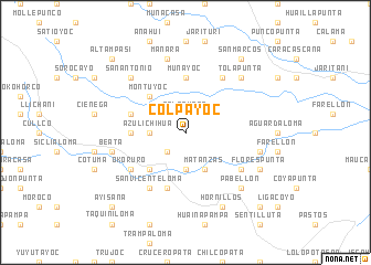
Colpayoc (Potosí, Bolivia)Colpayoc is a town in the Potosí region of Bolivia. An overview map of the region around Colpayoc is displayed below.
regional and 3d topo map of Colpayoc, Bolivia ::
Colpayoc airports ::
The nearest airport is TJA - Tarija Capitan Oriel Lea Plaza, located 151.9 km east of Colpayoc.
Other airports nearby include POI - Potosi Capitan Nicolas Rojas (204.9 km north), BJO - Bermejo (246.6 km south east), ORA - Oran (274.0 km south east), Nearby towns ::
Telapunta (1.9km north) //
Horauyoc (2.5km south west) //
Collpani (2.5km south west) //
San Jacinto (2.5km north west) //
Carapampa (2.5km north east) //
Azulichihua (3.5km west) //
Salle (3.7km south) //
Matanzas (4.1km south east) //
Nicolaspata (5.1km south west) //
Chilco (5.1km south west) //
Montuyoc (5.1km north west) //
Mojonputa (5.2km west) //
Muñayoc (5.6km north) //
Llañacasa (5.6km north) //
Crusana (5.8km south) //
Quehuino (5.5km west) //
Condor Chucuña (5.5km west) //
Yarilani (6.5km south west) //
San Vicenteloma (6.5km south west) //
Okoruro (6.4km south west) //
Queruta (6.5km north east) //
Chillcobija (6.4km south east) //
Cruz Pampa (7.1km east) //
Beata (7.1km west) //
Manara (7.6km north) //
San Antonio (7.6km north west) //
Pabellón (7.6km south east) //
Tolapunta (7.6km north east) //
Florespunta (7.8km south east) //
[all distances 'as the bird flies' and approximate] 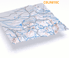 Places with similar names to Colpayoc, Bolivia :: Disclaimer :: Information on this page comes without warranty of any kind |
||
|
Where is Colpayoc? Elevation and coordinates ::
Latitude (lat): 21°21'0"S Longitude (lon): 66°9'0"W
Elevation (approx.): 4002m (map arrows pan, magnifying glasses zoom) |
||
|
Visiting Colpayoc? Hotel/Accommodation ::
Book a hotel in Colpayoc Travel Guide ::
Buy a travel guide for Bolivia rental cars ::
car rental offers GPS waypoint ::
download a GPX waypoint (PoI) of Colpayoc for your GPS receiver
|
||