|
search place name
|
||
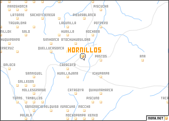
Hornillos (Potosí, Bolivia)Hornillos is a town in the Potosí region of Bolivia. An overview map of the region around Hornillos is displayed below.
regional and 3d topo map of Hornillos, Bolivia ::
Hornillos airports ::
The nearest airport is TJA - Tarija Capitan Oriel Lea Plaza, located 99.0 km east of Hornillos.
Other airports nearby include POI - Potosi Capitan Nicolas Rojas (194.8 km north), BJO - Bermejo (211.5 km south east), BYC - Yacuiba (216.2 km east), ORA - Oran (244.4 km south east), Nearby towns ::
Pastos (3.5km east) //
Atochuhuasiloma (4.1km north west) //
Caracota (3.9km south west) //
Quellacaca (3.9km north west) //
Huaillajara (5.1km south west) //
Ichupampa (5.1km south east) //
Millma Cancha (5.8km north) //
Mochara (5.8km north) //
Huailla (6.5km north west) //
Quellucasorca (7.2km west) //
Catagoya (7.6km south) //
Yanarumi (7.6km north west) //
Sirihorca (7.8km north west) //
Lagunilla (8.2km north west) //
Potrero (8.2km north east) //
Quihuinamarca (8.2km south east) //
[all distances 'as the bird flies' and approximate] 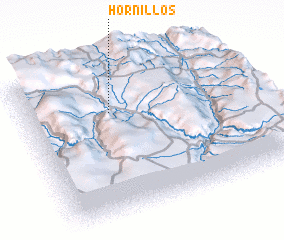 Places with similar names to Hornillos, Bolivia ::
Disclaimer :: Information on this page comes without warranty of any kind |
||
|
Where is Hornillos? Elevation and coordinates ::
Latitude (lat): 21°18'0"S Longitude (lon): 65°37'0"W
Elevation (approx.): 3474m (map arrows pan, magnifying glasses zoom) |
||
|
Visiting Hornillos? Hotel/Accommodation ::
Book a hotel in Hornillos Travel Guide ::
Buy a travel guide for Bolivia rental cars ::
car rental offers GPS waypoint ::
download a GPX waypoint (PoI) of Hornillos for your GPS receiver
|
||