|
search place name
|
||
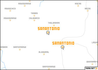
San Antonio (Chuquisaca, Bolivia)San Antonio is a town in the Chuquisaca region of Bolivia. An overview map of the region around San Antonio is displayed below.
regional and 3d topo map of San Antonio, Bolivia ::
San Antonio airports ::
The nearest airport is TJA - Tarija Capitan Oriel Lea Plaza, located 140.7 km south of San Antonio.
Other airports nearby include POI - Potosi Capitan Nicolas Rojas (162.9 km north west), SRE - Sucre Juana Azurduy De Padilla (172.3 km north west), BYC - Yacuiba (197.9 km south east), Nearby towns ::
Thola Pampa (4.1km north east) //
Algodonal (7.6km south) //
Calamarca (7.6km north west) //
San Antonio (7.6km south east) //
Tambos (9.1km north west) //
[all distances 'as the bird flies' and approximate] 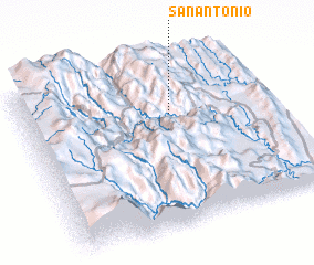 Places with similar names to San Antonio, Bolivia ::
// San Antônio (BR)
// San Antonio (BZ)
// San Antonio (BZ)
// San Antonio (BZ)
// San Antonio (BZ)
// San Antonio (US)
// San Antonio (US)
// San Antonio (US)
// San Antonio (PA)
// San Antonio (PA)
Disclaimer :: Information on this page comes without warranty of any kind |
||
|
Where is San Antonio? Elevation and coordinates ::
Latitude (lat): 20°19'0"S Longitude (lon): 64°24'0"W
Elevation (approx.): 2230m (map arrows pan, magnifying glasses zoom) |
||
|
Visiting San Antonio? Hotel/Accommodation ::
Book a hotel in San Antonio Travel Guide ::
Buy a travel guide for Bolivia rental cars ::
car rental offers GPS waypoint ::
download a GPX waypoint (PoI) of San Antonio for your GPS receiver
|
||