|
search place name
|
||
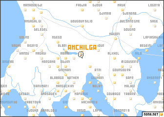
Amchilga (Cameroon)Amchilga is a town in Cameroon. An overview map of the region around Amchilga is displayed below.
regional and 3d topo map of Amchilga, Cameroon ::
Amchilga airports ::
The nearest airport is NDJ - N'djamena Ndjamena Hassan Djamous, located 83.4 km south east of Amchilga.
Other airports nearby include MIU - Maiduguri (160.4 km south west), Nearby towns ::
Zaman (1.8km west) //
Margi (1.9km north) //
Kasibé (1.9km north) //
Manda (1.9km north) //
Lisendjé (2.6km south east) //
Abari (3.6km west) //
Djadjaya (4.1km south west) //
Adjiri (4.1km south west) //
Albréla (4.1km north west) //
Soudour (4.1km north east) //
Grémari (5.2km south west) //
Atri (5.2km south east) //
Danaba Toumsa (5.4km west) //
Wathem (5.8km south) //
Barkari (5.7km west) //
Baouri (5.8km south) //
Goumari (6.6km south east) //
Ndégo (6.6km north west) //
Késawa (7.4km south) //
Dougoumsilio (7.4km north) //
Milié (7.2km east) //
Al Khel (7.2km east) //
Sambori (7.5km west) //
Margama (7.5km west) //
Dongolo (7.6km south) //
Blabago (7.8km south west) //
Mangachiri (8.2km south west) //
Bélay (8.2km south east) //
Afnami (8.1km south east) //
[all distances 'as the bird flies' and approximate]  Places with similar names to Amchilga, Cameroon :: Disclaimer :: Information on this page comes without warranty of any kind |
||
|
Where is Amchilga? Elevation and coordinates ::
Latitude (lat): 12°32'0"N Longitude (lon): 14°23'0"E
Elevation (approx.): 286m (map arrows pan, magnifying glasses zoom) |
||
|
Visiting Amchilga? Hotel/Accommodation ::
Book a hotel in Amchilga Travel Guide ::
Buy a travel guide for Cameroon rental cars ::
car rental offers GPS waypoint ::
download a GPX waypoint (PoI) of Amchilga for your GPS receiver
|
||