|
search place name
|
||
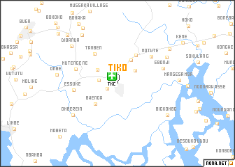
Tiko (South-West, Cameroon)Tiko is a town in the South-West region of Cameroon. An overview map of the region around Tiko is displayed below.
regional and 3d topo map of Tiko, Cameroon ::
Tiko airports ::
The nearest airport is TKC - Tiko, located 1.4 km north west of Tiko.
Other airports nearby include DLA - Douala (39.8 km east), SSG - Malabo (81.5 km south west), CBQ - Calabar (150.6 km north west), BFX - Bafoussam (194.9 km north east), Nearby towns ::
Holtforth (1.9km south west) //
Ndongo (3.0km west) //
Ikange (3.5km north east) //
Likomba (3.8km north west) //
Sone (4.3km north east) //
Bwenga (4.8km south west) //
Pungo (5.4km north east) //
Tamben (6.0km north west) //
Matute (6.9km north east) //
Mutengene (7.0km west) //
Essuke (7.1km west) //
Ebonji (7.6km east) //
Ombe Rein (8.6km south west) //
Manga (8.9km north east) //
Big Kombo (9.4km south east) //
Dibanda (9.5km north west) //
Bowanda (9.6km north west) //
Missellele (10.0km north east) //
Boniamavio (10.4km north west) //
Bolifamba (11.1km north west) //
[all distances 'as the bird flies' and approximate] 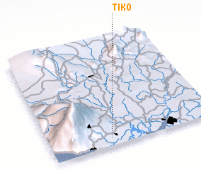 Places with similar names to Tiko, Cameroon ::
Disclaimer :: Information on this page comes without warranty of any kind |
||
|
Where is Tiko? Elevation and coordinates ::
Latitude (lat): 4°4'43"N Longitude (lon): 9°22'5"E
Elevation (approx.): 25m (map arrows pan, magnifying glasses zoom) |
||
|
Visiting Tiko? Hotel/Accommodation ::
Book a hotel in Tiko Travel Guide ::
Buy a travel guide for Cameroon rental cars ::
car rental offers GPS waypoint ::
download a GPX waypoint (PoI) of Tiko for your GPS receiver
|
||