|
search place name
|
||
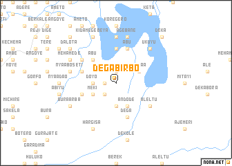
Dega Bīrbo (Ethiopia)Dega Bīrbo is a town in Ethiopia. An overview map of the region around Dega Bīrbo is displayed below.
regional and 3d topo map of Dega Bīrbo, Ethiopia ::
Dega Bīrbo airports ::
The nearest airport is ADD - Addis Ababa Bole Intl, located 45.1 km south west of Dega Bīrbo.
Nearby towns ::
Āderē (1.8km west) //
Kītī (1.8km west) //
Tʼumano (1.9km north) //
Galeyī (2.6km south west) //
Gogilē (3.7km south) //
Doyo (3.7km west) //
Ilēma (3.7km west) //
Āndodē (4.1km south east) //
Wanyaʼā (4.1km north east) //
Mekʼī (4.1km south west) //
Ābu (5.2km north west) //
Kara Kʼecha (5.2km north west) //
Horo (5.6km north) //
Dega (5.9km south) //
Tʼedē (5.9km north) //
Ābu (5.9km north) //
Gango (5.8km west) //
Kara Bīyo (5.8km west) //
Sekoro (6.6km north west) //
Āleltu (6.6km south east) //
Buʼī (7.4km north) //
Āgebanē (7.6km north) //
Nyaʼā Bosetī (7.5km west) //
Ukuyu (7.8km north east) //
Bura Ārba (8.2km south west) //
Mehāmedē (8.2km north west) //
Hargīsa (8.3km south west) //
Kʼidamē Gebeya (8.3km north west) //
Dalota (9.2km north west) //
[all distances 'as the bird flies' and approximate] 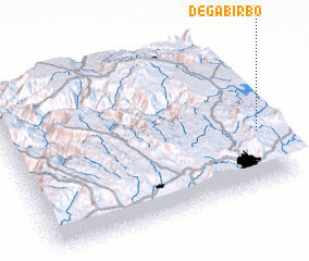 Places with similar names to Dega Bīrbo, Ethiopia :: Disclaimer :: Information on this page comes without warranty of any kind |
||
|
Where is Dega Bīrbo? Elevation and coordinates ::
Latitude (lat): 9°21'0"N Longitude (lon): 38°58'0"E
Elevation (approx.): 2733m (map arrows pan, magnifying glasses zoom) |
||
|
Visiting Dega Bīrbo? Hotel/Accommodation ::
Book a hotel in Dega Bīrbo Travel Guide ::
Buy a travel guide for Ethiopia rental cars ::
car rental offers GPS waypoint ::
download a GPX waypoint (PoI) of Dega Bīrbo for your GPS receiver
|
||