|
search place name
|
||
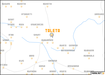
Tʼaleta (Ethiopia)Tʼaleta is a town in Ethiopia. An overview map of the region around Tʼaleta is displayed below.
regional and 3d topo map of Tʼaleta, Ethiopia ::
Tʼaleta airports ::
The nearest airport is MQX - Makale, located 67.1 km north of Tʼaleta.
Other airports nearby include LLI - Lalibella (127.4 km south west), AXU - Axum (172.1 km north west), Nearby towns ::
Deweyto (1.9km south) //
Mihilaw Sebela (2.6km south west) //
Ādadī Ārarē (2.6km south west) //
Hirka (4.1km south west) //
Golesha (4.1km south east) //
Ādī Āyo (5.2km south east) //
Simuny (5.4km west) //
Enda Corcos (6.6km north west) //
Boyē Gerarsa (7.8km south east) //
Weldayo (7.8km south east) //
Gerarsa (8.1km south east) //
Baro (10.4km south west) //
Kʼorbeta (10.5km south west) //
[all distances 'as the bird flies' and approximate] 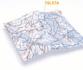 Places with similar names to Tʼaleta, Ethiopia ::
Disclaimer :: Information on this page comes without warranty of any kind |
||
|
Where is Tʼaleta? Elevation and coordinates ::
Latitude (lat): 12°53'0"N Longitude (lon): 39°42'0"E
Elevation (approx.): 1846m (map arrows pan, magnifying glasses zoom) |
||
|
Visiting Tʼaleta? Hotel/Accommodation ::
Book a hotel in Tʼaleta Travel Guide ::
Buy a travel guide for Ethiopia rental cars ::
car rental offers GPS waypoint ::
download a GPX waypoint (PoI) of Tʼaleta for your GPS receiver
|
||