|
search place name
|
||
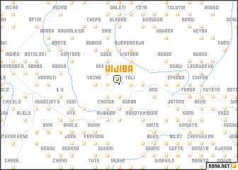
Wijiba (Ethiopia)Wijiba is a town in Ethiopia. An overview map of the region around Wijiba is displayed below.
regional and 3d topo map of Wijiba, Ethiopia ::
Wijiba airports ::
The nearest airport is ADD - Addis Ababa Bole Intl, located 97.3 km south of Wijiba.
Other airports nearby include BJR - Bahar Dar Bahir Dar (238.4 km north west), Nearby towns ::
Yaya (1.8km west) //
Kʼorkē (1.8km west) //
Tolī (1.8km east) //
Kʼamē (1.9km south) //
Bekolo (1.9km south) //
Ākebora (2.6km north west) //
Ānajuru (2.6km south west) //
Gubē (3.7km west) //
Yazha (3.7km west) //
Ēydu (3.7km east) //
Shabaya (3.7km east) //
Sobo (3.7km south) //
Godo (4.1km north west) //
Kīstana (4.1km north east) //
Gatīra (4.1km south west) //
Chʼangē (4.1km south west) //
Āsebo (4.1km south east) //
Humu (5.6km north) //
Kusho (5.6km north) //
Dukocho (5.6km south) //
Teklo (5.9km north) //
Inchʼinī (5.9km north) //
Chʼelelekʼa (5.9km north) //
Kʼultʼē (5.9km south) //
Ālīdero (5.9km south) //
Gara Yikē (5.9km south) //
Ējērē Bonja (5.9km north) //
Āno (5.8km east) //
Bubīsa (6.7km north west) //
[all distances 'as the bird flies' and approximate]  Places with similar names to Wijiba, Ethiopia ::
Disclaimer :: Information on this page comes without warranty of any kind |
||
|
Where is Wijiba? Elevation and coordinates ::
Latitude (lat): 9°49'0"N Longitude (lon): 38°32'0"E
Elevation (approx.): 2910m (map arrows pan, magnifying glasses zoom) |
||
|
Visiting Wijiba? Hotel/Accommodation ::
Book a hotel in Wijiba Travel Guide ::
Buy a travel guide for Ethiopia rental cars ::
car rental offers GPS waypoint ::
download a GPX waypoint (PoI) of Wijiba for your GPS receiver
|
||