|
search place name
|
||
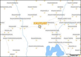
Khŭm Dar (Kâmpóng Cham, Cambodia)Khŭm Dar is a town in the Kâmpóng Cham region of Cambodia. An overview map of the region around Khŭm Dar is displayed below.
regional and 3d topo map of Khŭm Dar, Cambodia ::
Khŭm Dar airports ::
The nearest airport is SGN - Ho Chi Minh City Tansonnhat Intl, located 122.5 km south east of Khŭm Dar.
Other airports nearby include PNH - Phnom-penh Phnom Penh Intl (139.4 km west), Nearby towns ::
Phumĭ Khley (1.8km east) //
Phumĭ Sâmraông (4.1km north east) //
Phumĭ Châmkar Kausu (2) (5.6km north) //
Phumĭ Rôméas Chol (5.7km east) //
Phum Romduol (5.8km south) //
Phumĭ Spéan (6.6km north west) //
Phumĭ S'âm (7.3km west) //
Phumĭ Preăh Pônléa (7.5km east) //
Phumĭ Dák Pôr (7.5km east) //
Phumĭ Sala (7.6km north) //
Phumĭ Sotey (8.1km south east) //
Phumĭ Trâpeăng Reăng (9.1km north east) //
Phum Chipéay (9.1km south east) //
Phum Trâpeăng Sala (10.4km south east) //
Phumĭ Chéach (10.4km north east) //
[all distances 'as the bird flies' and approximate] 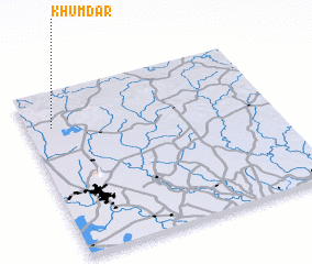
Disclaimer :: Information on this page comes without warranty of any kind |
||
|
Where is Khŭm Dar? Elevation and coordinates ::
Latitude (lat): 11°47'0"N Longitude (lon): 106°6'0"E
Elevation (approx.): 45m (map arrows pan, magnifying glasses zoom) |
||
|
Visiting Khŭm Dar? Hotel/Accommodation ::
Book a hotel in Khŭm Dar Travel Guide ::
Buy a travel guide for Cambodia rental cars ::
car rental offers GPS waypoint ::
download a GPX waypoint (PoI) of Khŭm Dar for your GPS receiver
|
||