|
search place name
|
||
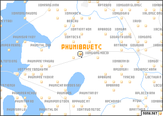
Phumĭ Bavĕt (2) (Svay Riĕng, Cambodia)Phumĭ Bavĕt (2) is a town in the Svay Riĕng region of Cambodia. An overview map of the region around Phumĭ Bavĕt (2) is displayed below.
regional and 3d topo map of Phumĭ Bavĕt (2), Cambodia ::
Phumĭ Bavĕt (2) airports ::
The nearest airport is SGN - Ho Chi Minh City Tansonnhat Intl, located 61.3 km south east of Phumĭ Bavĕt (2).
Other airports nearby include PNH - Phnom-penh Phnom Penh Intl (152.1 km west), Nearby towns ::
Phumĭ Bavĕt (1) (1.8km west) //
Xóm Ba Ao (2.6km north east) //
Xóm Giồng Mồ Côi (3.6km east) //
Ấp An Thuận (4.1km north east) //
Xóm Lai Thôm (4.1km north east) //
Xóm Tóc Sé (4.1km north west) //
Xóm Tiên Thôm (5.6km north) //
Ấp Rừng Ðan (5.6km north) //
Ấp Cái Tắc (6.6km north west) //
Ấp Bàu Lùng (6.6km south east) //
Bến Cầu (7.6km north) //
Phumĭ Kon Kôkir (7.5km west) //
Ấp Bào Gỏ (7.8km north east) //
Ấp Bàu Me (7.8km south east) //
Phumĭ Chrâk Smăch (7.8km south west) //
Ấp Long Huỳnh (8.3km north west) //
Ấp Bảo (8.3km north west) //
Phumĭ Chrâk Rœssei (8.3km south west) //
Ấp Phước Hưng (9.2km south east) //
Ấp Bàu Dưng (9.2km south east) //
Ấp Bá Mao (10.4km south east) //
[all distances 'as the bird flies' and approximate]  Places with similar names to Phumĭ Bavĕt (2), Cambodia :: Disclaimer :: Information on this page comes without warranty of any kind |
||
|
Where is Phumĭ Bavĕt (2)? Elevation and coordinates ::
Latitude (lat): 11°4'0"N Longitude (lon): 106°9'0"E
Elevation (approx.): 6m (map arrows pan, magnifying glasses zoom) |
||
|
Visiting Phumĭ Bavĕt (2)? Hotel/Accommodation ::
Book a hotel in Phumĭ Bavĕt (2) Travel Guide ::
Buy a travel guide for Cambodia rental cars ::
car rental offers GPS waypoint ::
download a GPX waypoint (PoI) of Phumĭ Bavĕt (2) for your GPS receiver
|
||