|
search place name
|
||
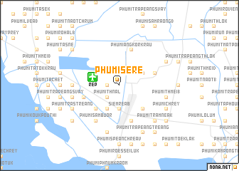
Phumĭ Sĕrĕ (Siĕm Réab, Cambodia)Phumĭ Sĕrĕ is a town in the Siĕm Réab region of Cambodia. An overview map of the region around Phumĭ Sĕrĕ is displayed below.
regional and 3d topo map of Phumĭ Sĕrĕ, Cambodia ::
Phumĭ Sĕrĕ airports ::
The nearest airport is REP - Siem-reap Siem Reap, located 4.2 km west of Phumĭ Sĕrĕ.
Other airports nearby include PNH - Phnom-penh Phnom Penh Intl (231.8 km south east), NAK - Nakhon Ratchasima Khorat (255.7 km north west), PKZ - Pakse (283.1 km north east), Nearby towns ::
Phumĭ Sâmraông (2) (1.8km west) //
Phumĭ Véal (1.9km north) //
Phumĭ Trâpeăng Séh Khang Lĕch (1.9km north) //
Phumĭ Thnál (2.6km south west) //
Phumĭ Koŭk Dong (2) (2.6km north east) //
Phumĭ Sândăn (3.6km west) //
Siĕmréab (3.7km south) //
Phumĭ Ta Phŭl (3.7km south) //
Phumĭ Kruŏs (4.1km south west) //
Phumĭ Spéan Ângkôr (4.1km north east) //
Phumĭ Prey Thum (5.2km south west) //
Phumĭ Réach Born (1) (5.2km south east) //
Phumĭ Ta Rós (5.7km west) //
Phumĭ Ângkôr Krau (5.8km north) //
Phumĭ Réach Born (2) (5.8km south) //
Phumĭ Krâvăn (5.7km east) //
Phumĭ Sâmbuŏr (6.6km south west) //
Phumĭ Prot (7.2km west) //
Phumĭ Kântrák (7.6km south) //
Phumĭ Poŭthĭ Bŏs (7.6km south) //
Phumĭ Svay (2) (7.4km west) //
Phumĭ Thmei (1) (7.4km east) //
Phumĭ Trăm Néak (7.8km south east) //
Phumĭ Prey Kroch (7.8km south east) //
Phumĭ Srăh Sráng (8.1km north east) //
Phumĭ Trás Treăng (8.1km south west) //
Phumĭ Chrey (8.1km south east) //
Phumĭ Trâpeăng Treăng (8.2km south east) //
Phumĭ Lbaeuk Ta So (9.1km north west) //
[all distances 'as the bird flies' and approximate] 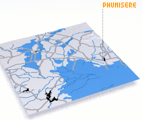 Places with similar names to Phumĭ Sĕrĕ, Cambodia ::
// Voymozero (RU)
// Võhmassaare (EE)
// Phumĭ Srăh (KH)
// Phumĭ Srê (KH)
// Phumĭ Srê (KH)
// Phumĭ Srê (KH)
// Phumĭ Srê (KH)
// Phumĭ Srê O (KH)
// Vaimsūr (IN)
// Vām Sāreh (IR)
Disclaimer :: Information on this page comes without warranty of any kind |
||
|
Where is Phumĭ Sĕrĕ? Elevation and coordinates ::
Latitude (lat): 13°24'0"N Longitude (lon): 103°51'0"E
Elevation (approx.): 21m (map arrows pan, magnifying glasses zoom) |
||
|
Visiting Phumĭ Sĕrĕ? Hotel/Accommodation ::
Book a hotel in Phumĭ Sĕrĕ Travel Guide ::
Buy a travel guide for Cambodia rental cars ::
car rental offers GPS waypoint ::
download a GPX waypoint (PoI) of Phumĭ Sĕrĕ for your GPS receiver
|
||