|
search place name
|
||
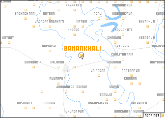
Bāmankhāli (Barisāl, Bangladesh)Bāmankhāli is a town in the Barisāl region of Bangladesh. An overview map of the region around Bāmankhāli is displayed below.
regional and 3d topo map of Bāmankhāli, Bangladesh ::
Bāmankhāli airports ::
The nearest airport is JSR - Jessore, located 34.2 km north of Bāmankhāli.
Other airports nearby include CCU - Calcutta Netaji Subhash Chandra Bose Intl (70.1 km west), IRD - Ishurdi (140.6 km north), DAC - Dhaka Zia Intl (171.4 km north east), RJH - Rajshahi Shah Mokhdum (178.6 km north), Nearby towns ::
Srīpatipur (2.5km south west) //
Kushādānga (2.5km north west) //
Tarulia (2.5km north east) //
Jainagar (5.0km south east) //
Gopsona (5.4km east) //
Khorda (5.8km north) //
Kālāroa (5.4km west) //
Ganapatipur (5.4km west) //
Rāipur (7.4km south) //
Mātsia (7.4km north) //
Dārbāsa (7.1km west) //
Kodanda (7.1km east) //
Alipur (7.6km north) //
Rudrapur (7.6km south west) //
Jhāudānga (8.2km south west) //
Chāndra (7.8km north east) //
Sārsa (10.1km south east) //
Jagadānandakāti (10.1km north west) //
[all distances 'as the bird flies' and approximate]  Places with similar names to Bāmankhāli, Bangladesh ::
Disclaimer :: Information on this page comes without warranty of any kind |
||
|
Where is Bāmankhāli? Elevation and coordinates ::
Latitude (lat): 22°53'0"N Longitude (lon): 89°5'0"E
Elevation (approx.): 5m (map arrows pan, magnifying glasses zoom) |
||
|
Visiting Bāmankhāli? Hotel/Accommodation ::
Book a hotel in Bāmankhāli Travel Guide ::
Buy a travel guide for Bangladesh rental cars ::
car rental offers GPS waypoint ::
download a GPX waypoint (PoI) of Bāmankhāli for your GPS receiver
|
||