|
search place name
|
||
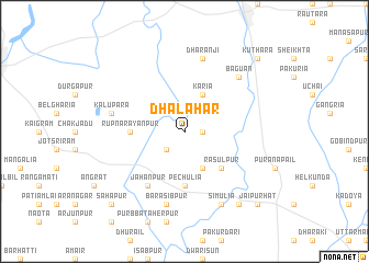
Dhalahar (Barisāl, Bangladesh)Dhalahar is a town in the Barisāl region of Bangladesh. An overview map of the region around Dhalahar is displayed below.
regional and 3d topo map of Dhalahar, Bangladesh ::
Dhalahar airports ::
The nearest airport is SPD - Saidpur, located 65.8 km north of Dhalahar.
Other airports nearby include RJH - Rajshahi Shah Mokhdum (87.6 km south west), IRD - Ishurdi (112.8 km south), COH - Cooch-behar Cooch Behar (139.0 km north), IXB - Baghdogra Bagdogra (179.0 km north), Nearby towns ::
Sekhpara (1.7km east) //
Pāhunanda (2.5km south west) //
Karia (4.1km north east) //
Bhatkola (4.1km south east) //
Rasulpur (5.0km south east) //
Rupnārāyanpur (5.0km west) //
Pechulia (5.6km south) //
Jāhānpur (6.5km south west) //
Dharanji (7.6km north) //
Kalupara (7.0km west) //
Barasibpur (7.6km south) //
Baguan (7.5km north east) //
Simulia (8.1km south east) //
Khanjanpur (9.0km south east) //
Jamuna (9.0km south east) //
Kuthāra (10.0km north east) //
Bāgjāna (10.0km north east) //
Sāhāpur (10.0km south west) //
Jaipur Hāt (10.0km south east) //
[all distances 'as the bird flies' and approximate] 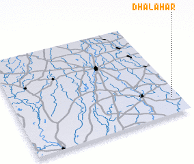 Places with similar names to Dhalahar, Bangladesh ::
Disclaimer :: Information on this page comes without warranty of any kind |
||
|
Where is Dhalahar? Elevation and coordinates ::
Latitude (lat): 25°10'0"N Longitude (lon): 88°57'0"E
Elevation (approx.): 22m (map arrows pan, magnifying glasses zoom) |
||
|
Visiting Dhalahar? Hotel/Accommodation ::
Book a hotel in Dhalahar Travel Guide ::
Buy a travel guide for Bangladesh rental cars ::
car rental offers GPS waypoint ::
download a GPX waypoint (PoI) of Dhalahar for your GPS receiver
|
||