|
search place name
|
||
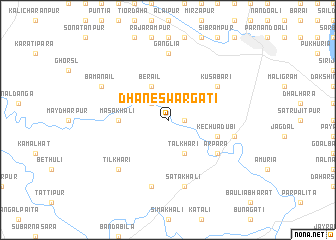
Dhaneswargāti (Barisāl, Bangladesh)Dhaneswargāti is a town in the Barisāl region of Bangladesh. An overview map of the region around Dhaneswargāti is displayed below.
regional and 3d topo map of Dhaneswargāti, Bangladesh ::
Dhaneswargāti airports ::
The nearest airport is JSR - Jessore, located 31.2 km south west of Dhaneswargāti.
Other airports nearby include IRD - Ishurdi (86.5 km north), DAC - Dhaka Zia Intl (118.5 km north east), CCU - Calcutta Netaji Subhash Chandra Bose Intl (124.0 km south west), RJH - Rajshahi Shah Mokhdum (134.5 km north west), Nearby towns ::
Rāghabdāir (1.7km east) //
Sāngda Lakshmīpur (2.5km north west) //
Berail (4.1km north west) //
Tālkhari (4.1km south east) //
Masakhāli (5.1km west) //
Kechuādubi (5.4km east) //
Kusābāri (6.3km north east) //
Ārpāra (6.3km south east) //
Gānglia (7.4km north) //
Chhāndra (7.6km south) //
Satakhāli (7.6km south) //
Jāgla (7.1km east) //
Tilkhari (7.5km south west) //
Bāmanāil (7.7km north west) //
[all distances 'as the bird flies' and approximate] 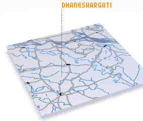 Places with similar names to Dhaneswargāti, Bangladesh :: Disclaimer :: Information on this page comes without warranty of any kind |
||
|
Where is Dhaneswargāti? Elevation and coordinates ::
Latitude (lat): 23°25'0"N Longitude (lon): 89°20'0"E
Elevation (approx.): 8m (map arrows pan, magnifying glasses zoom) |
||
|
Visiting Dhaneswargāti? Hotel/Accommodation ::
Book a hotel in Dhaneswargāti Travel Guide ::
Buy a travel guide for Bangladesh rental cars ::
car rental offers GPS waypoint ::
download a GPX waypoint (PoI) of Dhaneswargāti for your GPS receiver
|
||