|
search place name
|
||
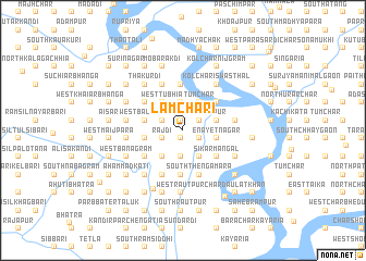
Lāmchari (Dhaka, Bangladesh)Lāmchari is a town in the Dhaka region of Bangladesh. An overview map of the region around Lāmchari is displayed below.
regional and 3d topo map of Lāmchari, Bangladesh ::
Lāmchari airports ::
The nearest airport is DAC - Dhaka Zia Intl, located 85.0 km north of Lāmchari.
Other airports nearby include JSR - Jessore (110.5 km west), IXA - Agartala (135.3 km north east), IRD - Ishurdi (168.7 km north west), CGP - Chittagong Shah Amanat Intl (187.0 km south east), Nearby towns ::
South Janārddandi (0.9km south) //
Jhāutala (0.9km south) //
Char Jhāutala (0.9km south) //
Mirākāndi (1.0km north) //
Rāmnagar (1.0km north) //
North Janārddandi (1.0km north) //
Char Lakshmi (1.7km south east) //
Char Sādipur (1.7km south east) //
Char Kāsimpur (1.7km south east) //
Lakshmipur Pakhira (1.7km south east) //
Char Krishnanagar (1.7km south east) //
Badardi (1.8km north east) //
Phulbari Gazāria (1.8km north east) //
South Kānāipur (1.8km north east) //
Kāsimpur (1.8km north east) //
Gadādhardi (1.8km north east) //
Kāshtagar (1.8km north east) //
Puāli Mādarīpur (2.1km south west) //
Rājdi (2.1km south west) //
East Bāligrām (2.2km north west) //
East Minājdi (2.2km north west) //
Khānjāpur (2.7km south) //
East Tubhia (2.9km north) //
East Mādra (2.9km north) //
Kālāimāra (2.9km north) //
Bibhāgdi (3.1km south east) //
Char Bibhāgdi (3.1km south east) //
Char Pāngāsia (3.1km south east) //
Char Thengamara (3.1km south east) //
[all distances 'as the bird flies' and approximate]  Places with similar names to Lāmchari, Bangladesh ::
Disclaimer :: Information on this page comes without warranty of any kind |
||
|
Where is Lāmchari? Elevation and coordinates ::
Latitude (lat): 23°5'27"N Longitude (lon): 90°14'7"E
Elevation (approx.): 9m (map arrows pan, magnifying glasses zoom) |
||
|
Visiting Lāmchari? Hotel/Accommodation ::
Book a hotel in Lāmchari Travel Guide ::
Buy a travel guide for Bangladesh rental cars ::
car rental offers GPS waypoint ::
download a GPX waypoint (PoI) of Lāmchari for your GPS receiver
|
||