|
search place name
|
||
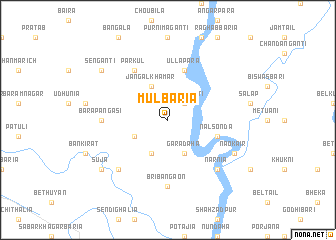
Mulbāria (Barisāl, Bangladesh)Mulbāria is a town in the Barisāl region of Bangladesh. An overview map of the region around Mulbāria is displayed below.
regional and 3d topo map of Mulbāria, Bangladesh ::
Mulbāria airports ::
The nearest airport is IRD - Ishurdi, located 52.4 km west of Mulbāria.
Other airports nearby include RJH - Rajshahi Shah Mokhdum (96.6 km west), DAC - Dhaka Zia Intl (98.1 km south east), JSR - Jessore (126.3 km south), IXA - Agartala (177.0 km east), Nearby towns ::
Singhagānti (2.5km north east) //
Dakshin Mohanpur (3.9km south west) //
Jangal Khāmār (4.1km north west) //
Chak Haripur (4.1km south west) //
Gārādāha (4.1km south east) //
Nalsonda (5.4km east) //
Ullāpāra (5.8km north) //
Pārkul (6.5km north west) //
Bri Bangaon (7.4km south) //
Bara Pāngāsi (6.8km west) //
Bri Dāpānia (7.5km south west) //
Narnia (7.5km south east) //
Nāokair (7.7km south east) //
Suja (8.8km south west) //
Sengānti (8.8km north west) //
[all distances 'as the bird flies' and approximate] 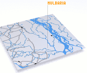 Places with similar names to Mulbāria, Bangladesh ::
Disclaimer :: Information on this page comes without warranty of any kind |
||
|
Where is Mulbāria? Elevation and coordinates ::
Latitude (lat): 24°16'0"N Longitude (lon): 89°33'0"E
Elevation (approx.): 15m (map arrows pan, magnifying glasses zoom) |
||
|
Visiting Mulbāria? Hotel/Accommodation ::
Book a hotel in Mulbāria Travel Guide ::
Buy a travel guide for Bangladesh rental cars ::
car rental offers GPS waypoint ::
download a GPX waypoint (PoI) of Mulbāria for your GPS receiver
|
||