|
search place name
|
||
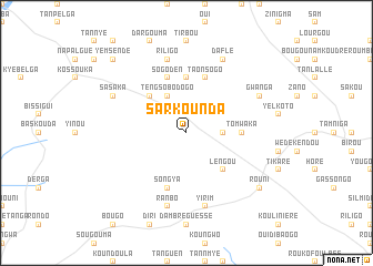
Sarkounda (Burkina Faso)Sarkounda is a town in Burkina Faso. An overview map of the region around Sarkounda is displayed below.
regional and 3d topo map of Sarkounda, Burkina Faso ::
Sarkounda airports ::
The nearest airport is OUA - Ouagadougou, located 111.1 km south of Sarkounda.
Nearby towns ::
Ansouri (3.6km east) //
Ipala (4.1km north east) //
Santaba (4.1km north west) //
Tengsobodogo (4.1km north west) //
Pendogou (5.2km north west) //
Kamtenga (5.2km north west) //
Lengou (5.2km south east) //
Boubou (5.6km north) //
Tomwaka (5.4km east) //
Sogoden (5.8km north) //
Taonsogo (5.8km north) //
Songya (5.8km south) //
Riligo (7.6km north) //
Ranbo (7.6km south) //
Yirim (7.6km south) //
Daflé (8.2km north east) //
Sasaka (8.1km north west) //
Gwanga (8.1km north east) //
Rouni (9.1km south east) //
Yemsende (10.3km north west) //
[all distances 'as the bird flies' and approximate]  Places with similar names to Sarkounda, Burkina Faso ::
// Şorkǝnd (AZ)
// Şurakǝnd (AZ)
// Şurakǝnd (AZ)
// Şurakǝnd (AZ)
// Cerro Cañito (PA)
// Saraykent (TR)
// Sarıkent (TR)
// Sarai Kānda (BD)
// Serkāndi (BD)
// Soārkāndi (BD)
Disclaimer :: Information on this page comes without warranty of any kind |
||
|
Where is Sarkounda? Elevation and coordinates ::
Latitude (lat): 13°19'0"N Longitude (lon): 1°48'0"W
Elevation (approx.): 332m (map arrows pan, magnifying glasses zoom) |
||
|
Visiting Sarkounda? Hotel/Accommodation ::
Book a hotel in Sarkounda Travel Guide ::
rental cars ::
car rental offers GPS waypoint ::
download a GPX waypoint (PoI) of Sarkounda for your GPS receiver
|
||