|
search place name
|
||
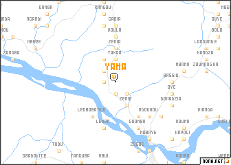
Yama (Central African Republic)Yama is a town in Central African Republic. An overview map of the region around Yama is displayed below.
regional and 3d topo map of Yama, Central African Republic ::
Yama airports ::
The nearest airport is BDT - Gbadolite, located 23.9 km south west of Yama.
Other airports nearby include GMA - Gemena (198.7 km south west), Nearby towns ::
Damba (1.8km west) //
Doussi (1.8km west) //
Banda (1.9km south) //
Gwakouzou (1.9km south) //
Botopa (2.6km north west) //
Sida (2.6km north west) //
Bodo (2.6km north west) //
Tengua (2.6km south east) //
Yakpa (3.7km north) //
Ndourouma (4.1km north west) //
Kandja (4.1km north west) //
Voula (4.1km north west) //
Yakpa (4.1km north west) //
Zenie (4.1km south east) //
Kolobo (4.1km south east) //
Bobi (4.1km south east) //
Bissoula (4.1km south east) //
Zenia (5.6km north) //
Legbobanga (6.7km south west) //
Goumba (6.7km south east) //
Dambolo (6.7km south east) //
Voula (7.4km north) //
Boulangba (7.4km north) //
Lembo (7.6km south) //
Ndouhou (7.9km south east) //
Goumba (8.3km south east) //
Diare (9.2km south east) //
[all distances 'as the bird flies' and approximate] 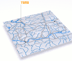 Places with similar names to Yama, Central African Republic ::
Disclaimer :: Information on this page comes without warranty of any kind |
||
|
Where is Yama? Elevation and coordinates ::
Latitude (lat): 4°24'0"N Longitude (lon): 21°8'0"E
Elevation (approx.): 403m (map arrows pan, magnifying glasses zoom) |
||
|
Visiting Yama? Hotel/Accommodation ::
Book a hotel in Yama Travel Guide ::
rental cars ::
car rental offers GPS waypoint ::
download a GPX waypoint (PoI) of Yama for your GPS receiver
|
||