|
search place name
|
||
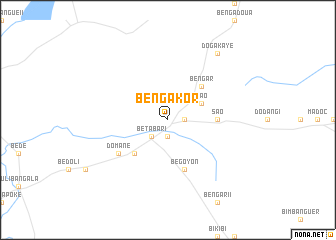
Bengakor (Logone Oriental, Chad)Bengakor is a town in the Logone Oriental region of Chad. An overview map of the region around Bengakor is displayed below.
regional and 3d topo map of Bengakor, Chad ::
Bengakor airports ::
The nearest airport is MQQ - Moundou, located 80.7 km north of Bengakor.
Nearby towns ::
Bésao (1.9km south) //
Betendil (1.8km east) //
Bésao II (1.9km south) //
Betabar I (2.6km south west) //
Sao (4.1km north east) //
Bembar (5.2km south west) //
Bengar (5.2km north east) //
Békao (5.5km east) //
Sao (5.5km east) //
Begoyon (5.9km south) //
Domane (6.6km south west) //
Dogakaye (9.2km north east) //
[all distances 'as the bird flies' and approximate]  Places with similar names to Bengakor, Chad ::
// Bang Kruai (TH)
// Bengakor (TD)
// Bengokari (TD)
// Bangkir (ID)
// Bingkor (MY)
// Bangou Karé (NE)
// Bongo Koyré (NE)
// Bankokoro (GN)
// Bankokoro (GN)
// Banko Koura (ML)
Disclaimer :: Information on this page comes without warranty of any kind |
||
|
Where is Bengakor? Elevation and coordinates ::
Latitude (lat): 7°54'0"N Longitude (lon): 15°59'0"E
Elevation (approx.): 494m (map arrows pan, magnifying glasses zoom) |
||
|
Visiting Bengakor? Hotel/Accommodation ::
Book a hotel in Bengakor Travel Guide ::
Buy a travel guide for Chad rental cars ::
car rental offers GPS waypoint ::
download a GPX waypoint (PoI) of Bengakor for your GPS receiver
|
||