|
search place name
|
||
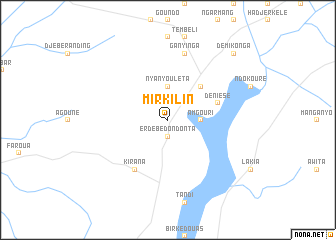
Mirkilin (Ouaddaï, Chad)Mirkilin is a town in the Ouaddaï region of Chad. An overview map of the region around Mirkilin is displayed below.
regional and 3d topo map of Mirkilin, Chad ::
Mirkilin airports ::
The nearest airport is AEH - Abeche, located 143.5 km north west of Mirkilin.
Nearby towns ::
Erdébé Dondonta (1.9km south) //
Echbara (1.9km north) //
Borota (2.6km north east) //
Nyanyouléta (3.7km north) //
Am Gouri (3.6km east) //
Goz Mérem (5.2km north east) //
Déniésé (5.7km east) //
Kirana (6.6km south west) //
Ganyinga (7.6km north) //
Démi Konga (10.4km north east) //
[all distances 'as the bird flies' and approximate] 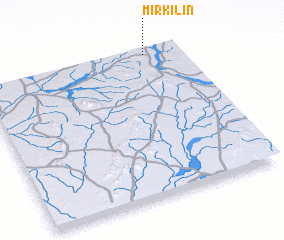 Places with similar names to Mirkilin, Chad ::
// Marraglione (IT)
// Mārkalne (LV)
// Mărculeni (RO)
// Marcaláin (ES)
// Marakulino (RU)
// Maur Kalān (IN)
// Maira Kalān (PK)
// Maira Kalān (PK)
// Māri Kalān (PK)
// Mirok Kalān (PK)
Disclaimer :: Information on this page comes without warranty of any kind |
||
|
Where is Mirkilin? Elevation and coordinates ::
Latitude (lat): 12°59'0"N Longitude (lon): 21°50'0"E
Elevation (approx.): 710m (map arrows pan, magnifying glasses zoom) |
||
|
Visiting Mirkilin? Hotel/Accommodation ::
Book a hotel in Mirkilin Travel Guide ::
Buy a travel guide for Chad rental cars ::
car rental offers GPS waypoint ::
download a GPX waypoint (PoI) of Mirkilin for your GPS receiver
|
||