|
search place name
|
||
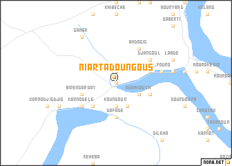
Niarta Doungous (Guéra, Chad)Niarta Doungous is a town in the Guéra region of Chad. An overview map of the region around Niarta Doungous is displayed below.
regional and 3d topo map of Niarta Doungous, Chad ::
Niarta Doungous airports ::
The nearest airport is AEH - Abeche, located 135.6 km north east of Niarta Doungous.
Nearby towns ::
Saounya (0.0km north) //
Niarta Kideyede (1.9km north) //
Koundour (3.7km south) //
Adamkouch (4.1km south east) //
Berdie (4.1km south east) //
Djemilasit (4.1km south east) //
Biren Andaraba (5.2km south west) //
Biren Amsalat (5.2km south west) //
Dafade (5.6km south) //
Am Dagagna (5.7km east) //
Biren Garday (5.7km west) //
Am Douroun (5.7km east) //
Am Dagig (6.6km north east) //
Djangoul (6.6km north east) //
Korno Dele (6.6km south west) //
Alfouro (7.5km east) //
Gamar (9.2km north west) //
[all distances 'as the bird flies' and approximate] 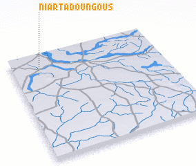 Places with similar names to Niarta Doungous, Chad :: Disclaimer :: Information on this page comes without warranty of any kind |
||
|
Where is Niarta Doungous? Elevation and coordinates ::
Latitude (lat): 12°49'0"N Longitude (lon): 20°10'0"E
Elevation (approx.): 441m (map arrows pan, magnifying glasses zoom) |
||
|
Visiting Niarta Doungous? Hotel/Accommodation ::
Book a hotel in Niarta Doungous Travel Guide ::
Buy a travel guide for Chad rental cars ::
car rental offers GPS waypoint ::
download a GPX waypoint (PoI) of Niarta Doungous for your GPS receiver
|
||