|
search place name
|
||
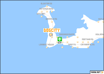
Dog City (Cayman Islands)Dog City is a town in Cayman Islands. An overview map of the region around Dog City is displayed below.
regional and 3d topo map of Dog City, Cayman Islands ::
Dog City airports ::
The nearest airport is GCM - Georgetown Owen Roberts Intl, located 2.8 km east of Dog City.
Other airports nearby include CYB - Cayman Barac Gerrard Smith Intl (163.2 km east), Nearby towns ::
George Town (0.0km north) //
Whitehall Estate (1.7km east) //
Rock Hole (1.7km east) //
Breezy Castle (1.7km east) //
Half Way Pond (2.5km south east) //
Lambert House (4.1km south west) //
Tropical Gardens (4.0km south east) //
Red Bay Estate (4.0km south east) //
Prospect (5.1km south east) //
Omega Gardens (5.2km east) //
Upper Land (5.6km north) //
Prospect Park (5.6km east) //
Spotts (7.9km south east) //
Coral Gables (8.2km north west) //
Vicksville (8.2km north west) //
West Bay (8.2km north west) //
[all distances 'as the bird flies' and approximate]  Places with similar names to Dog City, Cayman Islands ::
Disclaimer :: Information on this page comes without warranty of any kind |
||
|
Where is Dog City? Elevation and coordinates ::
Latitude (lat): 19°18'0"N Longitude (lon): 81°23'0"W
Elevation (approx.): -32768m (map arrows pan, magnifying glasses zoom) |
||
|
Visiting Dog City? Hotel/Accommodation ::
Book a hotel in Dog City Travel Guide ::
rental cars ::
car rental offers GPS waypoint ::
download a GPX waypoint (PoI) of Dog City for your GPS receiver
|
||