|
search place name
|
||
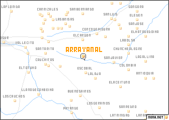
Arrayanal (Tolima, Colombia)Arrayanal is a town in the Tolima region of Colombia. An overview map of the region around Arrayanal is displayed below.
regional and 3d topo map of Arrayanal, Colombia ::
Arrayanal airports ::
The nearest airport is IBE - Ibague Perales, located 7.2 km west of Arrayanal.
Other airports nearby include AXM - Armenia El Eden (77.4 km west), MZL - Manizales La Nubia (82.0 km north west), PEI - Pereira Matecana (87.0 km north west), BOG - Bogota Eldorado Intl (107.7 km east), Nearby towns ::
Escobal (2.8km south) //
La Laja (4.6km south east) //
El Cardón (4.6km north) //
Guacán (5.6km west) //
Cerco de Piedra (6.4km north east) //
San Javier (6.5km east) //
Waterloo (6.9km north east) //
Buenos Aires (7.9km south) //
San Rafael (8.1km west) //
La Elisa (8.3km north west) //
Cauchitos (8.7km west) //
La Ceiba (8.8km north west) //
Santa Rita (8.8km west) //
Hato Viejo (9.0km north west) //
Las Brisas (9.2km north west) //
El Colegio (9.2km north west) //
El Aceituno (9.8km south east) //
Calubaima (9.9km north west) //
Los Cauchos (10.6km north east) //
Calicanto (10.9km north east) //
[all distances 'as the bird flies' and approximate] 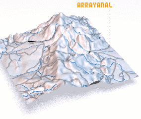 Places with similar names to Arrayanal, Colombia ::
Disclaimer :: Information on this page comes without warranty of any kind |
||
|
Where is Arrayanal? Elevation and coordinates ::
Latitude (lat): 4°24'9"N Longitude (lon): 75°4'15"W
Elevation (approx.): 762m (map arrows pan, magnifying glasses zoom) |
||
|
Visiting Arrayanal? Hotel/Accommodation ::
Book a hotel in Arrayanal Travel Guide ::
Buy a travel guide for Colombia rental cars ::
car rental offers GPS waypoint ::
download a GPX waypoint (PoI) of Arrayanal for your GPS receiver
|
||