|
search place name
|
||
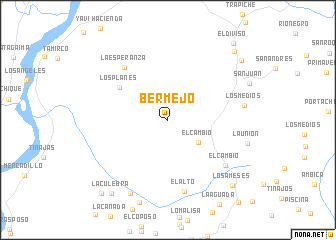
Bermejo (Tolima, Colombia)Bermejo is a town in the Tolima region of Colombia. An overview map of the region around Bermejo is displayed below.
regional and 3d topo map of Bermejo, Colombia ::
Bermejo airports ::
The nearest airport is NVA - Neiva Benito Salas, located 78.1 km south west of Bermejo.
Other airports nearby include IBE - Ibague Perales (97.6 km north), AXM - Armenia El Eden (134.7 km north west), BOG - Bogota Eldorado Intl (153.9 km north east), ULQ - Tulua Farfan (155.1 km west), Nearby towns ::
El Cambio (4.3km south east) //
Los Planes (6.6km north west) //
La Esperanza (7.7km north west) //
El Alto (8.2km south) //
El Cambio (8.2km south east) //
Los Medios (8.7km east) //
La Campana (9.2km south west) //
Los Ameses (10.3km south east) //
La Culebra (10.3km south west) //
Santa Librada (10.6km north east) //
Cimitarra (10.6km north east) //
Gaitán (11.1km south west) //
El Diviso (11.2km north east) //
[all distances 'as the bird flies' and approximate] 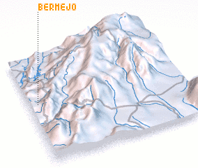 Places with similar names to Bermejo, Colombia ::
Disclaimer :: Information on this page comes without warranty of any kind |
||
|
Where is Bermejo? Elevation and coordinates ::
Latitude (lat): 3°33'38"N Longitude (lon): 74°56'28"W
Elevation (approx.): 1003m (map arrows pan, magnifying glasses zoom) |
||
|
Visiting Bermejo? Hotel/Accommodation ::
Book a hotel in Bermejo Travel Guide ::
Buy a travel guide for Colombia rental cars ::
car rental offers GPS waypoint ::
download a GPX waypoint (PoI) of Bermejo for your GPS receiver
|
||