|
search place name
|
||
Chivor (Boyacá, Colombia)Chivor is a town in the Boyacá region of Colombia. An overview map of the region around Chivor is displayed below.
regional and 3d topo map of Chivor, Colombia ::

Chivor airports ::
The nearest airport is VVC - Villavicencio Vanguardia, located 83.9 km south of Chivor.
Other airports nearby include BOG - Bogota Eldorado Intl (88.7 km west), IBE - Ibague Perales (202.4 km west), TME - Tame (248.4 km north east), NVA - Neiva Benito Salas (302.5 km south west), Nearby towns ::
Guali (3.1km east) //
Sinaí (3.2km south) //
Campamentos (4.1km south) //
San Cayetano (4.1km west) //
Boquerón de Chivor (4.4km north) //
Media Estancia (5.3km north) //
Cuerno de Oro (5.9km south west) //
Mundo Nuevo (6.1km south west) //
La Esperanza (6.2km south) //
San Antonio (6.8km south) //
Molinos (7.8km north west) //
Culima (7.9km south) //
Naranjos (8.6km north) //
Santa Rosa (8.6km south) //
El Eden (9.7km south west) //
San Sebastian (9.8km north west) //
[all distances 'as the bird flies' and approximate] 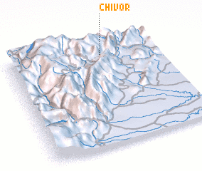 Places with similar names to Chivor, Colombia ::
Disclaimer :: Information on this page comes without warranty of any kind |
||
|
Where is Chivor? Elevation and coordinates ::
Latitude (lat): 4°53'8"N Longitude (lon): 73°22'8"W
Elevation (approx.): 1872m (map arrows pan, magnifying glasses zoom) |
||
|
Visiting Chivor? Hotel/Accommodation ::
Book a hotel in Chivor Travel Guide ::
Buy a travel guide for Colombia rental cars ::
car rental offers GPS waypoint ::
download a GPX waypoint (PoI) of Chivor for your GPS receiver
|
||