|
search place name
|
||
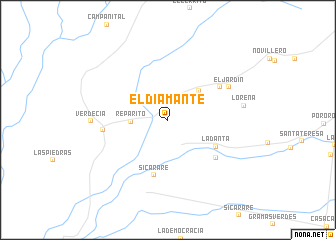
El Diamante (Cesar, Colombia)El Diamante is a town in the Cesar region of Colombia. An overview map of the region around El Diamante is displayed below.
regional and 3d topo map of El Diamante, Colombia ::
El Diamante airports ::
The nearest airport is VUP - Valledupar Alfonso Lopez Pumarejo, located 58.1 km north of El Diamante.
Other airports nearby include SMR - Santa Marta Simon Bolivar (157.9 km north west), MGN - Magangue Baracoa (172.2 km south west), OCV - Ocana Aguas Claras (179.6 km south), BAQ - Barranquilla Ernesto Cortissoz (182.3 km north west), Nearby towns ::
Reparito (4.1km west) //
Vayan Viendo (4.7km north east) //
La Danta (6.1km south east) //
Sicarare (6.4km south) //
Guadalajara (6.8km south east) //
El Calvario (6.8km north east) //
Sabana Alta (7.2km west) //
El Jardín (7.6km north east) //
Verdecia (8.5km west) //
Lorena (8.5km east) //
[all distances 'as the bird flies' and approximate]  Places with similar names to El Diamante, Colombia ::
// El Diamante (CU)
// El Diamante (CU)
// El Diamante (CO)
// El Diamante (CO)
// El Diamante (CO)
// El Diamante (CO)
// El Diamante (CO)
// El Diamante (CO)
// El Diamante (CO)
// El Diamante (CO)
Disclaimer :: Information on this page comes without warranty of any kind |
||
|
Where is El Diamante? Elevation and coordinates ::
Latitude (lat): 9°56'16"N Longitude (lon): 73°25'18"W
Elevation (approx.): 61m (map arrows pan, magnifying glasses zoom) |
||
|
Visiting El Diamante? Hotel/Accommodation ::
Book a hotel in El Diamante Travel Guide ::
Buy a travel guide for Colombia rental cars ::
car rental offers GPS waypoint ::
download a GPX waypoint (PoI) of El Diamante for your GPS receiver
|
||