|
search place name
|
||
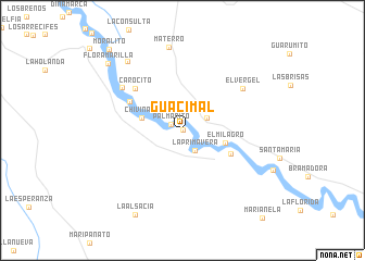
Guacimal (Departamento de Casanare, Colombia)Guacimal is a town in the Departamento de Casanare region of Colombia. An overview map of the region around Guacimal is displayed below.
regional and 3d topo map of Guacimal, Colombia ::
Guacimal airports ::
The nearest airport is VVC - Villavicencio Vanguardia, located 173.7 km west of Guacimal.
Other airports nearby include TME - Tame (203.8 km north), Nearby towns ::
Guasimal (0.0km north) //
Palmarito (1.3km north west) //
La Primavera (2.4km south east) //
Corocito (2.8km north east) //
Chivinave (4.3km west) //
Chavinave (4.3km west) //
El Milagro (4.6km east) //
Guafalpintado (5.5km south east) //
Tierra Grata (6.2km north west) //
Carocito (6.5km north west) //
El Vergel (7.6km north east) //
Altamira (7.6km north west) //
Materro (8.7km north) //
Grano de Arena (9.1km north west) //
La Alsacia (9.9km south west) //
Flor Amarilla (10.3km north west) //
Moralito (11.3km north west) //
[all distances 'as the bird flies' and approximate]  Places with similar names to Guacimal, Colombia ::
// Kasymly (AZ)
// Kazımlı (AZ)
// Qasimbǝyli (AZ)
// Qasımbǝyli (AZ)
// Qasımbǝyli (AZ)
// Qasımbeyli (AZ)
// Qasımlı (AZ)
// Qasımlı (AZ)
// Keys Mill (US)
// Gosaumühle (AT)
Disclaimer :: Information on this page comes without warranty of any kind |
||
|
Where is Guacimal? Elevation and coordinates ::
Latitude (lat): 4°38'41"N Longitude (lon): 72°7'22"W
Elevation (approx.): 162m (map arrows pan, magnifying glasses zoom) |
||
|
Visiting Guacimal? Hotel/Accommodation ::
Book a hotel in Guacimal Travel Guide ::
Buy a travel guide for Colombia rental cars ::
car rental offers GPS waypoint ::
download a GPX waypoint (PoI) of Guacimal for your GPS receiver
|
||