|
search place name
|
||
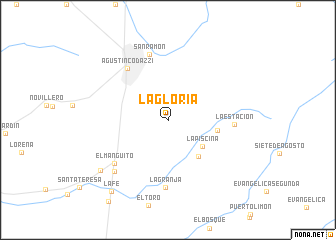
La Gloria (Cesar, Colombia)La Gloria is a town in the Cesar region of Colombia. An overview map of the region around La Gloria is displayed below.
regional and 3d topo map of La Gloria, Colombia ::
La Gloria airports ::
The nearest airport is VUP - Valledupar Alfonso Lopez Pumarejo, located 50.2 km north of La Gloria.
Other airports nearby include SMR - Santa Marta Simon Bolivar (169.0 km north west), MAR - Maracaibo La Chinita Intl (173.1 km east), RCH - Rio Hacha Almirante Padilla (173.1 km north), STB - Santa Barbara Del Zulia (177.4 km south east), Nearby towns ::
La Piscina (4.8km south east) //
La Amapola (5.2km south east) //
La Pradera (5.5km east) //
Agustín Codazzi (7.3km north west) //
La Estación (7.4km east) //
La Granja (7.5km south) //
San Ramón (7.6km north) //
El Manguito (7.7km south west) //
Las Mercedes (8.3km south west) //
Pororó (9.3km south west) //
La Fe (10.1km south west) //
[all distances 'as the bird flies' and approximate] 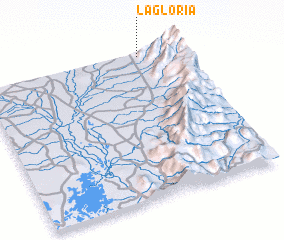 Places with similar names to La Gloria, Colombia ::
Disclaimer :: Information on this page comes without warranty of any kind |
||
|
Where is La Gloria? Elevation and coordinates ::
Latitude (lat): 9°59'4"N Longitude (lon): 73°11'52"W
Elevation (approx.): 242m (map arrows pan, magnifying glasses zoom) |
||
|
Visiting La Gloria? Hotel/Accommodation ::
Book a hotel in La Gloria Travel Guide ::
Buy a travel guide for Colombia rental cars ::
car rental offers GPS waypoint ::
download a GPX waypoint (PoI) of La Gloria for your GPS receiver
|
||