|
search place name
|
||
La Rayita (Cesar, Colombia)La Rayita is a town in the Cesar region of Colombia. An overview map of the region around La Rayita is displayed below.
regional and 3d topo map of La Rayita, Colombia ::

La Rayita airports ::
The nearest airport is OCV - Ocana Aguas Claras, located 84.2 km south of La Rayita.
Other airports nearby include MGN - Magangue Baracoa (136.3 km west), VUP - Valledupar Alfonso Lopez Pumarejo (161.5 km north), CUC - Cucuta Camilo Daza (173.2 km south east), LFR - La Fria (173.4 km south east), Nearby towns ::
La Raya (1.6km north) //
Recreo (2.0km south) //
La Evidencia (2.1km north) //
Rivera (4.6km west) //
Mata de Barrio (5.0km west) //
La Victoria (5.2km north) //
Guamal (6.0km north west) //
Las Vegas (6.4km north) //
Pailitas (6.6km south) //
Riveral (6.7km west) //
Rivera (7.8km west) //
Soledad (8.2km north west) //
Aguacatal (8.5km north) //
Las Brisas (8.6km north west) //
El Castillo (8.6km north west) //
Tinajita (8.6km west) //
Santa María (8.8km north) //
La Siria (9.8km south west) //
[all distances 'as the bird flies' and approximate] 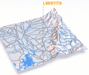 Places with similar names to La Rayita, Colombia :: Disclaimer :: Information on this page comes without warranty of any kind |
||
|
Where is La Rayita? Elevation and coordinates ::
Latitude (lat): 9°1'31"N Longitude (lon): 73°38'2"W
Elevation (approx.): 86m (map arrows pan, magnifying glasses zoom) |
||
|
Visiting La Rayita? Hotel/Accommodation ::
Book a hotel in La Rayita Travel Guide ::
Buy a travel guide for Colombia rental cars ::
car rental offers GPS waypoint ::
download a GPX waypoint (PoI) of La Rayita for your GPS receiver
|
||