|
search place name
|
||
Los Laureles (Boyacá, Colombia)Los Laureles is a town in the Boyacá region of Colombia. An overview map of the region around Los Laureles is displayed below.
regional and 3d topo map of Los Laureles, Colombia ::

Los Laureles airports ::
The nearest airport is MDE - Rio Negro Jose Maria Cordova, located 112.6 km west of Los Laureles.
Other airports nearby include BOG - Bogota Eldorado Intl (125.3 km south), EOH - Medellin Olaya Herrera (132.1 km west), MZL - Manizales La Nubia (137.4 km south west), OTU - Otu (138.1 km north), Nearby towns ::
Bellavista (1.2km north east) //
Aguanegro (1.3km south east) //
La Mesita (1.5km south) //
Las Penas (1.9km north east) //
San Fernando (2.0km south) //
Santa Lucía (2.3km south) //
La Esperanza (2.8km north east) //
Borugas (3.4km north) //
Los Limones (3.4km south east) //
La Belleza (3.4km north east) //
Puerto Abarco (3.8km east) //
San Francisco (4.1km south east) //
Caño Hondo (4.2km south east) //
Villa Tranquile (4.5km south) //
Casa de Zinc (4.9km south) //
La Aurora (5.1km south east) //
El Trapiche (5.4km east) //
Terán (5.8km south) //
El Agrado (6.0km north east) //
Los Naranjos (6.1km east) //
La Fortuna (6.2km south east) //
El Turpial (6.4km north east) //
La Primavera (6.5km east) //
Patio Bonito (6.5km north east) //
Pozo Rico (7.0km east) //
Patevaca (7.4km east) //
La Primavera (7.5km north east) //
La Esperanza (7.5km north east) //
El Diamante (7.6km north) //
[all distances 'as the bird flies' and approximate] 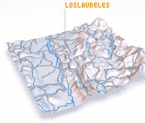 Places with similar names to Los Laureles, Colombia ::
// Los Laureles (CU)
// Los Laureles (CL)
// Los Laureles (CL)
// Los Laureles (CL)
// Los Laureles (CO)
// Los Laureles (CO)
// Los Laureles (CO)
// Los Laureles (CO)
// Los Laureles (CO)
// Los Laureles (CO)
Disclaimer :: Information on this page comes without warranty of any kind |
||
|
Where is Los Laureles? Elevation and coordinates ::
Latitude (lat): 5°47'3"N Longitude (lon): 74°28'48"W
Elevation (approx.): 216m (map arrows pan, magnifying glasses zoom) |
||
|
Visiting Los Laureles? Hotel/Accommodation ::
Book a hotel in Los Laureles Travel Guide ::
Buy a travel guide for Colombia rental cars ::
car rental offers GPS waypoint ::
download a GPX waypoint (PoI) of Los Laureles for your GPS receiver
|
||