|
search place name
|
||
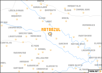
Mata Azul (Cundinamarca, Colombia)Mata Azul is a town in the Cundinamarca region of Colombia. An overview map of the region around Mata Azul is displayed below.
regional and 3d topo map of Mata Azul, Colombia ::
Mata Azul airports ::
The nearest airport is VVC - Villavicencio Vanguardia, located 48.6 km west of Mata Azul.
Other airports nearby include BOG - Bogota Eldorado Intl (117.1 km north west), SJE - San Jose Del Guaviare Jorge E Gonzalez Torres (195.9 km south), IBE - Ibague Perales (216.8 km west), Nearby towns ::
Ceiba Negra (1.6km north west) //
La Comba (2.1km east) //
La Paz (4.5km north) //
La Esmeralda (5.0km south) //
Maracaibo (5.5km west) //
Guacavia (6.0km south east) //
El Viso (6.5km north west) //
Mirabel (6.5km south west) //
El Tigre (7.3km south west) //
Aracal (7.9km north east) //
Piñalito (7.9km south west) //
Los Paraguayes (8.3km east) //
Quién Quita (8.5km north) //
El Güio (10.7km north east) //
Arrecifes (11.2km south west) //
[all distances 'as the bird flies' and approximate]  Places with similar names to Mata Azul, Colombia ::
Disclaimer :: Information on this page comes without warranty of any kind |
||
|
Where is Mata Azul? Elevation and coordinates ::
Latitude (lat): 4°15'49"N Longitude (lon): 73°11'11"W
Elevation (approx.): 214m (map arrows pan, magnifying glasses zoom) |
||
|
Visiting Mata Azul? Hotel/Accommodation ::
Book a hotel in Mata Azul Travel Guide ::
Buy a travel guide for Colombia rental cars ::
car rental offers GPS waypoint ::
download a GPX waypoint (PoI) of Mata Azul for your GPS receiver
|
||