|
search place name
|
||
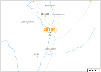
Potosí (Caquetá, Colombia)Potosí is a town in the Caquetá region of Colombia. An overview map of the region around Potosí is displayed below.
regional and 3d topo map of Potosí, Colombia ::
Potosí airports ::
The nearest airport is FLA - Florencia Gustavo Artunduaga Paredes, located 22.0 km north west of Potosí.
Other airports nearby include SVI - San Vincente De Caguan Eduardo Falla Solano (112.6 km north east), PUU - Puerto Asis Tres De Mayo (153.0 km south west), NVA - Neiva Benito Salas (170.7 km north), PPN - Popayan Guillermo Leon Valencia (171.3 km north west), Nearby towns ::
La Reserva (5.6km south) //
Corleón (7.6km north) //
La Montañita (7.8km north east) //
Milán (9.1km south west) //
La Esperanza (9.6km north west) //
[all distances 'as the bird flies' and approximate] 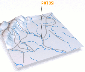 Places with similar names to Potosí, Colombia ::
Disclaimer :: Information on this page comes without warranty of any kind |
||
|
Where is Potosí? Elevation and coordinates ::
Latitude (lat): 1°25'0"N Longitude (lon): 75°28'0"W
Elevation (approx.): 225m (map arrows pan, magnifying glasses zoom) |
||
|
Visiting Potosí? Hotel/Accommodation ::
Book a hotel in Potosí Travel Guide ::
Buy a travel guide for Colombia rental cars ::
car rental offers GPS waypoint ::
download a GPX waypoint (PoI) of Potosí for your GPS receiver
|
||