|
search place name
|
||
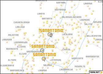
San Antonio (Santander, Colombia)San Antonio is a town in the Santander region of Colombia. An overview map of the region around San Antonio is displayed below.
regional and 3d topo map of San Antonio, Colombia ::
San Antonio airports ::
The nearest airport is BGA - Bucaramanga Palonegro, located 87.9 km north of San Antonio.
Other airports nearby include EJA - Barrancabermeja Yariguies (89.8 km north west), OTU - Otu (167.3 km north west), TME - Tame (176.7 km east), SVZ - San Antonio Del Tachira (193.4 km north east), Nearby towns ::
San Antonio (0.4km west) //
Santa Ana (1.4km north west) //
San Francisco (1.5km south) //
San Javier (1.8km south east) //
La Floresta (1.9km north west) //
Los Cacaos (2.1km north) //
Chima (2.3km west) //
Santa Lucía (2.6km south east) //
Fundamento (2.6km south west) //
La Esperanza (2.7km east) //
San Martín (2.7km south east) //
El Hobito (2.7km north west) //
Carare (2.8km south east) //
La Reforma (2.9km west) //
Guapota Viejo (3.0km north east) //
Macana (3.1km south west) //
Caracolí (3.1km west) //
Buenavista (3.1km west) //
San Ignacio (3.4km south) //
El Llano (3.4km south west) //
Larure (3.4km south west) //
Santo Tomás (3.5km south west) //
San Pedro (3.5km north west) //
Laguneta (3.8km north west) //
Palencia (3.9km north) //
San Agustín (3.9km south west) //
Guamal (3.9km north west) //
Guarata (4.0km south) //
San Pedro (4.0km south west) //
[all distances 'as the bird flies' and approximate] 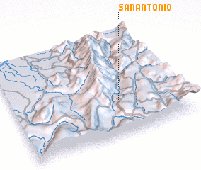 Places with similar names to San Antonio, Colombia ::
// San Antônio (BR)
// San Antonio (BZ)
// San Antonio (BZ)
// San Antonio (BZ)
// San Antonio (BZ)
// San Antonio (US)
// San Antonio (US)
// San Antonio (US)
// San Antonio (PA)
// San Antonio (PA)
Disclaimer :: Information on this page comes without warranty of any kind |
||
|
Where is San Antonio? Elevation and coordinates ::
Latitude (lat): 6°21'0"N Longitude (lon): 73°21'15"W
Elevation (approx.): 856m (map arrows pan, magnifying glasses zoom) |
||
|
Visiting San Antonio? Hotel/Accommodation ::
Book a hotel in San Antonio Travel Guide ::
Buy a travel guide for Colombia rental cars ::
car rental offers GPS waypoint ::
download a GPX waypoint (PoI) of San Antonio for your GPS receiver
|
||