|
search place name
|
||
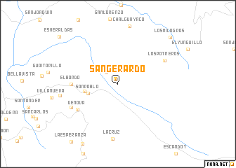
San Gerardo (Nariño, Colombia)San Gerardo is a town in the Nariño region of Colombia. An overview map of the region around San Gerardo is displayed below.
regional and 3d topo map of San Gerardo, Colombia ::
San Gerardo airports ::
The nearest airport is PSO - Pasto Antonio Narino, located 48.1 km south west of San Gerardo.
Other airports nearby include PPN - Popayan Guillermo Leon Valencia (94.1 km north east), IPI - Ipiales San Luis (120.0 km south west), TUA - Tulcan Teniente Coronel Luis A Mantilla (127.1 km south west), PUU - Puerto Asis Tres De Mayo (140.2 km south), Nearby towns ::
Briceño (2.6km north west) //
San Pablo (5.0km west) //
San Pablo (5.4km west) //
El Bordo (7.4km west) //
Genova (7.6km south west) //
Sebastianillo (8.3km south west) //
Los Potreros (8.3km north east) //
La Cruz (8.8km south) //
Los Milagros (11.2km north east) //
[all distances 'as the bird flies' and approximate] 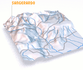 Places with similar names to San Gerardo, Colombia ::
// San Gerardo (CO)
// San Gerardo (CO)
// San Gerardo (CO)
// San Gerardo (CO)
// San Gerardo (CO)
// San Gerardo (CR)
// San Gerardo (CR)
// San Gerardo (CR)
// San Gerardo (CR)
// San Gerardo (CR)
Disclaimer :: Information on this page comes without warranty of any kind |
||
|
Where is San Gerardo? Elevation and coordinates ::
Latitude (lat): 1°41'0"N Longitude (lon): 76°58'0"W
Elevation (approx.): 2039m (map arrows pan, magnifying glasses zoom) |
||
|
Visiting San Gerardo? Hotel/Accommodation ::
Book a hotel in San Gerardo Travel Guide ::
Buy a travel guide for Colombia rental cars ::
car rental offers GPS waypoint ::
download a GPX waypoint (PoI) of San Gerardo for your GPS receiver
|
||