|
search place name
|
||
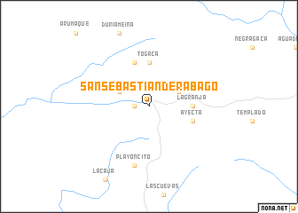
San Sebastián de Rábago (Magdalena, Colombia)San Sebastián de Rábago is a town in the Magdalena region of Colombia. An overview map of the region around San Sebastián de Rábago is displayed below.
regional and 3d topo map of San Sebastián de Rábago, Colombia ::
San Sebastián de Rábago airports ::
The nearest airport is VUP - Valledupar Alfonso Lopez Pumarejo, located 41.0 km east of San Sebastián de Rábago.
Other airports nearby include SMR - Santa Marta Simon Bolivar (92.2 km north west), RCH - Rio Hacha Almirante Padilla (129.2 km north east), BAQ - Barranquilla Ernesto Cortissoz (134.0 km west), MGN - Magangue Baracoa (196.9 km south west), Nearby towns ::
Pantano (1.8km west) //
Atiquimaqueca (4.1km north east) //
Sicariuca (4.1km north west) //
La Granja (5.5km east) //
Togaca (5.6km north) //
Ayecta (5.8km east) //
Coquigaca (5.9km north) //
Chocorugüe (5.9km north) //
Playoncito (7.6km south) //
[all distances 'as the bird flies' and approximate] 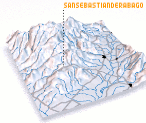 Places with similar names to San Sebastián de Rábago, Colombia :: Disclaimer :: Information on this page comes without warranty of any kind |
||
|
Where is San Sebastián de Rábago? Elevation and coordinates ::
Latitude (lat): 10°34'0"N Longitude (lon): 73°36'0"W
Elevation (approx.): 1985m (map arrows pan, magnifying glasses zoom) |
||
|
Visiting San Sebastián de Rábago? Hotel/Accommodation ::
Book a hotel in San Sebastián de Rábago Travel Guide ::
Buy a travel guide for Colombia rental cars ::
car rental offers GPS waypoint ::
download a GPX waypoint (PoI) of San Sebastián de Rábago for your GPS receiver
|
||