|
search place name
|
||
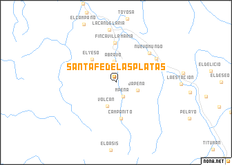
Santa Fé de Las Platas (Antioquia, Colombia)Santa Fé de Las Platas is a town in the Antioquia region of Colombia. An overview map of the region around Santa Fé de Las Platas is displayed below.
regional and 3d topo map of Santa Fé de Las Platas, Colombia ::
Santa Fé de Las Platas airports ::
The nearest airport is MTR - Monteria Los Garzones, located 72.8 km east of Santa Fé de Las Platas.
Other airports nearby include CZU - Corozal Las Brujas (151.8 km north east), MGN - Magangue Baracoa (191.9 km north east), CTG - Cartagena Rafael Nunez (229.7 km north east), OTU - Otu (257.7 km south east), Nearby towns ::
M Peña (2.6km south east) //
A Bravo (3.4km north) //
J A Peña (3.7km east) //
Volcán (4.0km south) //
El Yeso (5.4km north west) //
Campanito (5.9km south) //
Finca Villa Maria (6.4km north) //
Nuevo Mundo (7.2km north east) //
El Carmelo (7.5km north east) //
La Candelaria (8.6km north) //
[all distances 'as the bird flies' and approximate] 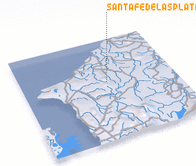 Places with similar names to Santa Fé de Las Platas, Colombia :: Disclaimer :: Information on this page comes without warranty of any kind |
||
|
Where is Santa Fé de Las Platas? Elevation and coordinates ::
Latitude (lat): 8°34'53"N Longitude (lon): 76°26'27"W
Elevation (approx.): 68m (map arrows pan, magnifying glasses zoom) |
||
|
Visiting Santa Fé de Las Platas? Hotel/Accommodation ::
Book a hotel in Santa Fé de Las Platas Travel Guide ::
Buy a travel guide for Colombia rental cars ::
car rental offers GPS waypoint ::
download a GPX waypoint (PoI) of Santa Fé de Las Platas for your GPS receiver
|
||