|
search place name
|
||
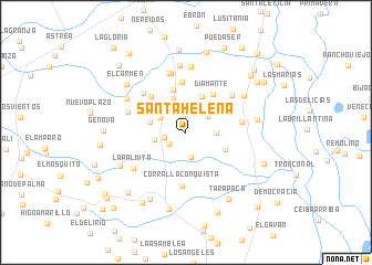
SantaHelena (Cesar, Colombia)SantaHelena is a town in the Cesar region of Colombia. An overview map of the region around SantaHelena is displayed below.
regional and 3d topo map of SantaHelena, Colombia ::
SantaHelena airports ::
The nearest airport is MGN - Magangue Baracoa, located 108.6 km west of SantaHelena.
Other airports nearby include VUP - Valledupar Alfonso Lopez Pumarejo (130.8 km north east), OCV - Ocana Aguas Claras (134.8 km south east), CZU - Corozal Las Brujas (156.1 km west), BAQ - Barranquilla Ernesto Cortissoz (190.6 km north west), Nearby towns ::
Monte Bello (1.6km north) //
El Canal (2.1km south west) //
Palmira (2.2km west) //
El Palmar (2.5km south) //
Buenaventura (2.7km north east) //
La Pradera (2.8km north) //
Santa Lucia (3.0km north west) //
El Brillante (3.0km east) //
Campo Alegre (3.2km north west) //
Las Margaritaso (3.2km west) //
Inverna (3.3km north east) //
El Encanto (3.6km north) //
Capitolio (3.7km west) //
Villa Nueva (3.9km north east) //
SanPacho (4.3km south east) //
La Esperanza (4.4km north) //
Diamante (4.7km north east) //
El Topacio (5.0km north west) //
La Esperanza (5.1km north) //
Corral La Conquista (5.4km south) //
Inverna (5.7km east) //
Santanita (5.8km north west) //
Cielo Azul (5.9km north east) //
Carolina (6.1km north) //
MaríaLuisa (6.1km west) //
El Descanso (6.2km north) //
La Palmita (6.3km south west) //
El Jobo (6.7km north) //
Casablanca (6.8km north) //
[all distances 'as the bird flies' and approximate] 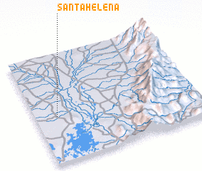 Places with similar names to SantaHelena, Colombia ::
// Santa Helena (BR)
// Santa Helena (BR)
// Santa Helena (BR)
// Santa Helena (BR)
// Santa Helena (BR)
// Santa Helena (BR)
// Santa Helena (BR)
// Santa Helena (BR)
// Santa Helena (BR)
// Santa Helena (BR)
Disclaimer :: Information on this page comes without warranty of any kind |
||
|
Where is SantaHelena? Elevation and coordinates ::
Latitude (lat): 9°25'24"N Longitude (lon): 73°52'3"W
Elevation (approx.): 62m (map arrows pan, magnifying glasses zoom) |
||
|
Visiting SantaHelena? Hotel/Accommodation ::
Book a hotel in SantaHelena Travel Guide ::
Buy a travel guide for Colombia rental cars ::
car rental offers GPS waypoint ::
download a GPX waypoint (PoI) of SantaHelena for your GPS receiver
|
||