|
search place name
|
||
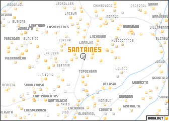
Santa Inés (Huila, Colombia)Santa Inés is a town in the Huila region of Colombia. An overview map of the region around Santa Inés is displayed below.
regional and 3d topo map of Santa Inés, Colombia ::
Santa Inés airports ::
The nearest airport is FLA - Florencia Gustavo Artunduaga Paredes, located 71.4 km south east of Santa Inés.
Other airports nearby include PPN - Popayan Guillermo Leon Valencia (92.1 km west), NVA - Neiva Benito Salas (104.0 km north east), SVI - San Vincente De Caguan Eduardo Falla Solano (118.2 km east), CLO - Cali Alfonso Bonilla Aragon Intl (163.0 km north), Nearby towns ::
Lagunillas (1.7km east) //
Buenos Aires (1.9km west) //
Jagualito (2.4km north east) //
El Tambo (2.6km north west) //
La Alegría (2.8km west) //
La Palma (3.1km north) //
Topochera (3.4km south) //
La Muralla (3.5km south) //
La Cabaña (3.6km south) //
Versalles (3.7km east) //
Rica Brisa (4.1km west) //
San José (4.4km north east) //
El Congo (4.6km north east) //
El Carmen (4.7km south) //
San Joaquín (5.2km north) //
Betania (5.2km west) //
La Chamba (5.3km north east) //
Las Mercedes (5.3km south) //
El Arrayán (5.6km north east) //
Lagunilla (5.6km north east) //
Buenavista (5.6km north west) //
Eureka (5.7km north west) //
Lejanía (5.9km north west) //
San José (6.3km west) //
El Mirador (6.4km east) //
Lourdes (6.4km south west) //
San Nicolás (6.4km south) //
La Estrellita (6.4km west) //
El Boquerón (6.5km south west) //
[all distances 'as the bird flies' and approximate]  Places with similar names to Santa Inés, Colombia ::
// Santa Inês (BR)
// Santa Inês (BR)
// Santa Inês (BR)
// Santo Inácio (BR)
// Santo Inácio (BR)
// Santo Inácio (BR)
// Santo Inácio (BR)
// Santo Inácio (BR)
// Santo Inácio (BR)
// Santa Ynez (US)
Disclaimer :: Information on this page comes without warranty of any kind |
||
|
Where is Santa Inés? Elevation and coordinates ::
Latitude (lat): 2°10'41"N Longitude (lon): 75°49'42"W
Elevation (approx.): 1021m (map arrows pan, magnifying glasses zoom) |
||
|
Visiting Santa Inés? Hotel/Accommodation ::
Book a hotel in Santa Inés Travel Guide ::
Buy a travel guide for Colombia rental cars ::
car rental offers GPS waypoint ::
download a GPX waypoint (PoI) of Santa Inés for your GPS receiver
|
||