|
search place name
|
||
Zabaletas (Valle del Cauca, Colombia)Zabaletas is a town in the Valle del Cauca region of Colombia. An overview map of the region around Zabaletas is displayed below.
regional and 3d topo map of Zabaletas, Colombia ::

Zabaletas airports ::
The nearest airport is CLO - Cali Alfonso Bonilla Aragon Intl, located 40.0 km south east of Zabaletas.
Other airports nearby include BUN - Buenaventura Gerardo Tobar Lopez (40.5 km west), ULQ - Tulua Farfan (53.1 km north east), AXM - Armenia El Eden (118.9 km north east), PEI - Pereira Matecana (148.2 km north east), Nearby towns ::
Bajo Sabaletas (1.2km north east) //
San Salvador (1.4km south east) //
Tragedias (1.4km south east) //
Los Cedros (5.3km north east) //
Santa Lucía (5.5km south east) //
Potrerillo (6.6km east) //
Román (6.7km south east) //
Lobo Guerrero (6.8km south west) //
La Chapa (7.0km west) //
Argentina (7.0km west) //
Madroñal (9.4km north east) //
Atuncela (9.8km south west) //
Puerta Dagua (10.7km south west) //
[all distances 'as the bird flies' and approximate] 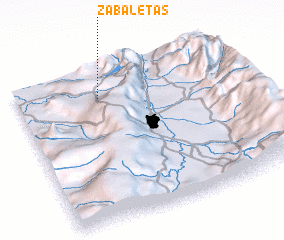 Places with similar names to Zabaletas, Colombia ::
// Zabelitsy (RU)
// Zeublitz (DE)
// Zöblitz (DE)
// Zoblitz (DE)
// Zabłędza (PL)
// Zabłotce (PL)
// Zbłudza (PL)
// Zablotse (UA)
// Zabolottsy (UA)
// Zabolottsy (UA)
Disclaimer :: Information on this page comes without warranty of any kind |
||
|
Where is Zabaletas? Elevation and coordinates ::
Latitude (lat): 3°48'35"N Longitude (lon): 76°37'30"W
Elevation (approx.): 1176m (map arrows pan, magnifying glasses zoom) |
||
|
Visiting Zabaletas? Hotel/Accommodation ::
Book a hotel in Zabaletas Travel Guide ::
Buy a travel guide for Colombia rental cars ::
car rental offers GPS waypoint ::
download a GPX waypoint (PoI) of Zabaletas for your GPS receiver
|
||