|
search place name
|
||
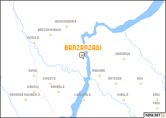
Banza-Nzadi (Congo, Democratic Republic of the)Banza-Nzadi is a town in Congo, Democratic Republic of the. An overview map of the region around Banza-Nzadi is displayed below.
regional and 3d topo map of Banza-Nzadi, Congo, Democratic Republic of the ::
Banza-Nzadi airports ::
The nearest airport is SSY - M'banza-congo Mbanza Congo, located 132.6 km south of Banza-Nzadi.
Other airports nearby include BZV - Brazzaville Maya Maya (169.2 km north east), NLO - Kinshasa Ndolo (171.9 km north east), FIH - Kinshasa Ndjili Intl (180.3 km north east), MNB - Muanda (202.8 km south west), Nearby towns ::
Madimba (5.2km south east) //
Bidi-Kindamba (8.3km north west) //
Banza-Kimbuku (9.2km north west) //
Kingoyo (9.2km south west) //
Matende (9.2km south east) //
Pambala (9.3km south west) //
[all distances 'as the bird flies' and approximate] 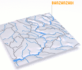 Places with similar names to Banza-Nzadi, Congo, Democratic Republic of the ::
// Benson East (US)
// Ban Sènsatè (LA)
Disclaimer :: Information on this page comes without warranty of any kind |
||
|
Where is Banza-Nzadi? Elevation and coordinates ::
Latitude (lat): 5°6'0"S Longitude (lon): 13°59'0"E
Elevation (approx.): 263m (map arrows pan, magnifying glasses zoom) |
||
|
Visiting Banza-Nzadi? Hotel/Accommodation ::
Book a hotel in Banza-Nzadi Travel Guide ::
rental cars ::
car rental offers GPS waypoint ::
download a GPX waypoint (PoI) of Banza-Nzadi for your GPS receiver
|
||