|
search place name
|
||
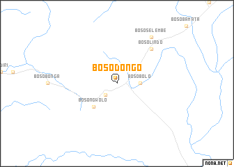
Bosodongo (Congo, Democratic Republic of the)Bosodongo is a town in Congo, Democratic Republic of the. An overview map of the region around Bosodongo is displayed below.
regional and 3d topo map of Bosodongo, Congo, Democratic Republic of the ::
Bosodongo airports ::
The nearest airport is GMA - Gemena, located 105.4 km south of Bosodongo.
Other airports nearby include BDT - Gbadolite (123.3 km east), BGF - Bangui M Poko (151.5 km west), Nearby towns ::
Bosokamo (2.6km south west) //
Bosobolo (3.7km east) //
Bosongwolo (5.2km south west) //
Bosolindo (7.9km north east) //
Bososelembe (9.3km north east) //
[all distances 'as the bird flies' and approximate]  Places with similar names to Bosodongo, Congo, Democratic Republic of the ::
// Busdongo (ES)
// Besedinka (RU)
// Bostānak (IR)
// Būstānak (IR)
// Basèotenga (BF)
// Bésetenga (BF)
// Bosuadongo (CD)
// Busu-Dongo (CD)
// Besitang (ID)
// Bisitinga (GH)
Disclaimer :: Information on this page comes without warranty of any kind |
||
|
Where is Bosodongo? Elevation and coordinates ::
Latitude (lat): 4°11'0"N Longitude (lon): 19°52'0"E
Elevation (approx.): 451m (map arrows pan, magnifying glasses zoom) |
||
|
Visiting Bosodongo? Hotel/Accommodation ::
Book a hotel in Bosodongo Travel Guide ::
rental cars ::
car rental offers GPS waypoint ::
download a GPX waypoint (PoI) of Bosodongo for your GPS receiver
|
||