|
search place name
|
||
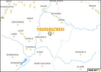
Youngou-Zassi (Kouilou, Congo, Republic of the)Youngou-Zassi is a town in the Kouilou region of Congo, Republic of the. An overview map of the region around Youngou-Zassi is displayed below.
regional and 3d topo map of Youngou-Zassi, Congo, Republic of the ::
Youngou-Zassi airports ::
The nearest airport is PNR - Pointe-noire Pointe Noire, located 41.5 km south west of Youngou-Zassi.
Other airports nearby include CAB - Cabinda (106.0 km south), MNB - Muanda (143.7 km south), SZA - Soyo (167.0 km south), Nearby towns ::
Louvenza (0.6km north) //
Masséla (1.2km north east) //
Mvéso (1.9km north east) //
Boubisi (3.9km south west) //
Koukouala (3.9km west) //
Songo (6.6km north east) //
Movoumba (7.7km north) //
Djéba (7.9km south west) //
Kivoula (8.2km west) //
Tchivoula (8.9km south west) //
Mbaka (9.5km north west) //
Bambala (10.0km south west) //
[all distances 'as the bird flies' and approximate] 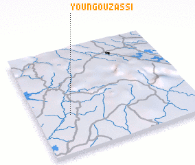 Places with similar names to Youngou-Zassi, Congo, Republic of the ::
Disclaimer :: Information on this page comes without warranty of any kind |
||
|
Where is Youngou-Zassi? Elevation and coordinates ::
Latitude (lat): 4°38'19"S Longitude (lon): 12°12'59"E
Elevation (approx.): 56m (map arrows pan, magnifying glasses zoom) |
||
|
Visiting Youngou-Zassi? Hotel/Accommodation ::
Book a hotel in Youngou-Zassi Travel Guide ::
rental cars ::
car rental offers GPS waypoint ::
download a GPX waypoint (PoI) of Youngou-Zassi for your GPS receiver
|
||