|
search place name
|
||
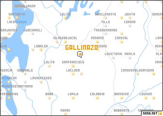
Gallinazo (Los Ríos, Ecuador)Gallinazo is a town in the Los Ríos region of Ecuador. An overview map of the region around Gallinazo is displayed below.
regional and 3d topo map of Gallinazo, Ecuador ::
Gallinazo airports ::
The nearest airport is GYE - Guayaquil Jose Joaquin De Olmedo Intl, located 59.6 km south west of Gallinazo.
Other airports nearby include PVO - Portoviejo Reales Tamarindos (121.3 km north west), ATF - Ambato Chachoan (126.2 km north east), MEC - Manta Eloy Alfaro Intl (146.2 km north west), CUE - Cuenca Mariscal Lamar (148.3 km south east), Nearby towns ::
San Francisco (2.6km south west) //
Chapulo (3.7km south) //
Juana de Oro (4.1km north east) //
La Clara (4.1km south west) //
Rosario (5.2km north east) //
Isla de Bejucal (5.2km north west) //
Achiote (6.7km north west) //
Julia (7.4km east) //
La Victoria (7.4km east) //
Lolita (7.6km west) //
Tres Hermanas (7.9km north east) //
Las Mercedes (7.9km north east) //
Tillo (9.3km north east) //
San Juan (9.3km north east) //
[all distances 'as the bird flies' and approximate] 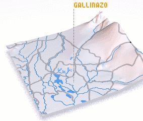 Places with similar names to Gallinazo, Ecuador ::
Disclaimer :: Information on this page comes without warranty of any kind |
||
|
Where is Gallinazo? Elevation and coordinates ::
Latitude (lat): 1°42'0"S Longitude (lon): 79°36'0"W
Elevation (approx.): 13m (map arrows pan, magnifying glasses zoom) |
||
|
Visiting Gallinazo? Hotel/Accommodation ::
Book a hotel in Gallinazo Travel Guide ::
Buy a travel guide for Ecuador rental cars ::
car rental offers GPS waypoint ::
download a GPX waypoint (PoI) of Gallinazo for your GPS receiver
|
||