|
search place name
|
||
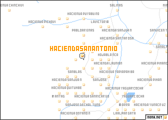
Hacienda San Antonio (Imbabura, Ecuador)Hacienda San Antonio is a town in the Imbabura region of Ecuador. An overview map of the region around Hacienda San Antonio is displayed below.
regional and 3d topo map of Hacienda San Antonio, Ecuador ::
Hacienda San Antonio airports ::
The nearest airport is TUA - Tulcan Teniente Coronel Luis A Mantilla, located 67.7 km north east of Hacienda San Antonio.
Other airports nearby include UIO - Quito Mariscal Sucre Intl (72.8 km south west), IPI - Ipiales San Luis (74.4 km north east), PSO - Pasto Antonio Narino (145.5 km north east), TCO - Tumaco La Florida (162.8 km north), Nearby towns ::
Tumbabiro (1.9km north) //
Urcuquí (1.9km south) //
Hacienda Pigunchuela (1.9km south) //
Hacienda La Banda (1.9km east) //
Hacienda San Francisco (1.9km west) //
Hacienda San Clemente (2.6km north east) //
Hacienda San Nicolás (2.6km south east) //
Hacienda El Ingenio (3.7km north) //
Hacienda San Carlos (3.7km east) //
Hacienda Añaburo (4.1km south west) //
Hacienda San Eloy (4.1km south east) //
San Blas (4.1km south west) //
Hacienda Pisangacho (4.1km south west) //
Hacienda Santa Isabel (4.1km south east) //
Hacienda La Florida (5.2km south west) //
Hoja Blanca (5.6km east) //
Pablo Arenas (5.6km north) //
Hacienda Mindaburlo (5.6km south) //
Hacienda La Unión (5.9km east) //
Hacienda San Juan (6.7km south west) //
Hacienda San Vicente (6.7km south east) //
San José (6.7km south east) //
Hacienda Alobuela (7.4km south) //
Hacienda Santiago del Rey (7.6km south) //
Hacienda Coñaquí (7.6km south) //
Hacienda El Puente (7.9km south east) //
Hacienda El Hospital (7.9km south west) //
Cahuasquí (8.3km north west) //
Hacienda Quitumbe (8.3km south west) //
[all distances 'as the bird flies' and approximate] 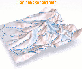 Places with similar names to Hacienda San Antonio, Ecuador ::
// Hacienda San Antonio (PH)
// Hacienda San Antonio (EC)
// Hacienda San Antonio (EC)
// Hacienda San Antonio (EC)
// Hacienda San Antonio (EC)
// Hacienda San Antonio (EC)
// Hacienda San Antonio (EC)
// Hacienda San Antonio (EC)
// Hacienda San Antonio (EC)
// Hacienda San Antonio (EC)
Disclaimer :: Information on this page comes without warranty of any kind |
||
|
Where is Hacienda San Antonio? Elevation and coordinates ::
Latitude (lat): 0°27'0"S Longitude (lon): 78°12'0"W
Elevation (approx.): 2229m (map arrows pan, magnifying glasses zoom) |
||
|
Visiting Hacienda San Antonio? Hotel/Accommodation ::
Book a hotel in Hacienda San Antonio Travel Guide ::
Buy a travel guide for Ecuador rental cars ::
car rental offers GPS waypoint ::
download a GPX waypoint (PoI) of Hacienda San Antonio for your GPS receiver
|
||