|
search place name
|
||
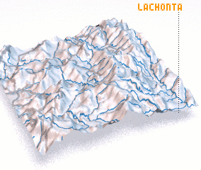
La Chonta (Zamora-Chinchipe, Ecuador)La Chonta is a town in the Zamora-Chinchipe region of Ecuador. An overview map of the region around La Chonta is displayed below.
regional and 3d topo map of La Chonta, Ecuador ::

La Chonta airports ::
The nearest airport is PIU - Piura Capitan Fap Guillermo Concha Iberico, located 170.5 km west of La Chonta.
Other airports nearby include CHH - Chachapoyas (195.3 km south east), MCH - Machala General Manuel Serrano (209.1 km north west), TBP - Tumbes Pedro Canga (210.0 km north west), CIX - Chiclayo Capt Jose A Quinones Gonzales Intl (218.6 km south), Nearby towns ::
 Places with similar names to La Chonta, Ecuador ::
// Le Chainet (FR)
// Lechinţa (RO)
// Lechinţa (RO)
// Lechinţa (RO)
// La Chonta (EC)
// La Chonta (EC)
// La Chonita (MX)
// Le Chenit (CH)
// Luchente (ES)
// Lochend (GB)
Disclaimer :: Information on this page comes without warranty of any kind |
||
|
Where is La Chonta? Elevation and coordinates ::
Latitude (lat): 4°57'0"S Longitude (lon): 79°6'0"W
Elevation (approx.): 935m (map arrows pan, magnifying glasses zoom) |
||
|
Visiting La Chonta? Hotel/Accommodation ::
Book a hotel in La Chonta Travel Guide ::
Buy a travel guide for Ecuador rental cars ::
car rental offers GPS waypoint ::
download a GPX waypoint (PoI) of La Chonta for your GPS receiver
|
||