|
search place name
|
||
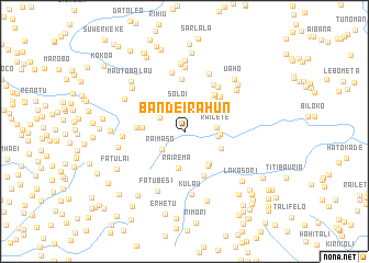
Bandeirahun (Timor Timur, East Timor)Bandeirahun is a town in the Timor Timur region of East Timor. An overview map of the region around Bandeirahun is displayed below.
regional and 3d topo map of Bandeirahun, East Timor ::
Bandeirahun airports ::
The nearest airport is DIL - Dili Presidente Nicolau Lobato Intl, located 23.5 km north of Bandeirahun.
Nearby towns ::
Soloi (2.8km north) //
Raimaso (2.9km south west) //
Maurusa (2.9km north west) //
Railete (3.3km east) //
Raifusu (3.4km east) //
Dailor (3.6km east) //
Rairema (3.8km south) //
Kabasfatin (3.9km north east) //
Bibteron (4.1km south east) //
Denehuni (4.2km south east) //
Lahae (4.3km south east) //
Maurusa (4.3km west) //
Malere (4.3km north east) //
Aileu (4.6km north east) //
Acolimamate (4.8km west) //
Aileukota (4.8km north east) //
Fatubossa (4.9km south east) //
Aissirimou (5.1km north east) //
Kotbauru (5.4km north) //
Aitoi (5.6km north east) //
Aitularan (5.6km north east) //
Siliboro (6.1km north) //
Ouelae (6.3km west) //
Quintaportugal (6.4km north east) //
Kulau (6.5km south) //
Lidulalan (6.5km north) //
Fatubesi (6.7km south west) //
Sidole (6.7km north east) //
Rekoalepa (6.8km north) //
[all distances 'as the bird flies' and approximate] 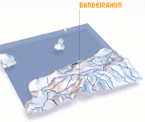 Places with similar names to Bandeirahun, East Timor ::
// Banderahun (TP)
// Bandarahena (LK)
Disclaimer :: Information on this page comes without warranty of any kind |
||
|
Where is Bandeirahun? Elevation and coordinates ::
Latitude (lat): 8°45'30"S Longitude (lon): 125°32'18"E
Elevation (approx.): 957m (map arrows pan, magnifying glasses zoom) |
||
|
Visiting Bandeirahun? Hotel/Accommodation ::
Book a hotel in Bandeirahun Travel Guide ::
Buy a travel guide for East Timor rental cars ::
car rental offers GPS waypoint ::
download a GPX waypoint (PoI) of Bandeirahun for your GPS receiver
|
||