|
search place name
|
||
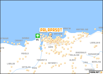
Palapasot (Timor Timur, East Timor)Palapasot is a town in the Timor Timur region of East Timor. An overview map of the region around Palapasot is displayed below.
regional and 3d topo map of Palapasot, East Timor ::
Palapasot airports ::
The nearest airport is DIL - Dili Presidente Nicolau Lobato Intl, located 4.9 km west of Palapasot.
Nearby towns ::
Aitarak (0.4km west) //
Parol (0.4km south) //
Bebora (0.6km south west) //
Bairo Alto (0.6km south) //
Karketu (0.9km west) //
Moro (0.9km west) //
Vila Verde (0.9km south) //
Mata Doro (1.0km south) //
Dili (1.1km south east) //
Caicoli (1.1km south) //
Lafandaria (1.2km south) //
Fatuhada (1.3km west) //
Virdolosa (1.4km south) //
Bairo Pite (1.5km south west) //
Banderahun (1.5km south) //
Borohun (1.5km south east) //
Perumnas (1.5km south) //
Tuanalaran (1.6km south) //
Audian (1.6km south east) //
Hudilaran (1.7km south west) //
Balide (1.8km south) //
Rumbia (1.8km south east) //
Ailelehun (1.9km south east) //
Manumeta Rahun (1.9km south) //
Quintal Qik (1.9km south east) //
Bispo Medeiros (1.9km south east) //
Markoni (1.9km west) //
Bedik (1.9km west) //
Ailoklaran (1.9km south west) //
[all distances 'as the bird flies' and approximate] 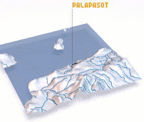 Places with similar names to Palapasot, East Timor :: Disclaimer :: Information on this page comes without warranty of any kind |
||
|
Where is Palapasot? Elevation and coordinates ::
Latitude (lat): 8°32'59"S Longitude (lon): 125°34'9"E
Elevation (approx.): 4m (map arrows pan, magnifying glasses zoom) |
||
|
Visiting Palapasot? Hotel/Accommodation ::
Book a hotel in Palapasot Travel Guide ::
Buy a travel guide for East Timor rental cars ::
car rental offers GPS waypoint ::
download a GPX waypoint (PoI) of Palapasot for your GPS receiver
|
||