|
search place name
|
||
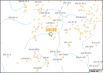
Uaiae (Timor Timur, East Timor)Uaiae is a town in the Timor Timur region of East Timor. An overview map of the region around Uaiae is displayed below.
regional and 3d topo map of Uaiae, East Timor ::
Uaiae airports ::
The nearest airport is DIL - Dili Presidente Nicolau Lobato Intl, located 99.9 km west of Uaiae.
Nearby towns ::
Uatumissa (0.8km north) //
Lulibau (1.2km east) //
Larameta (1.3km south east) //
Acakuata (1.5km north west) //
Daule (1.9km north) //
Uaicana (3.1km north) //
Kaubai (3.9km north west) //
Liabala (3.9km north) //
Ossogori (4.0km north) //
Luhaoli (4.1km north) //
Ariana (4.1km north) //
Uaibobo (4.7km north east) //
Kaihurulale (4.7km north west) //
Uailaha (5.0km north west) //
Leo (5.4km east) //
Uaitoco (5.5km north east) //
Uanisi (5.5km east) //
Baru (5.7km north west) //
Betecaiana (5.8km west) //
Umaanaico (5.8km north west) //
Uatuasa (5.8km north west) //
Henihuta (5.8km west) //
Cailetiana (5.8km west) //
Venilale (5.9km north west) //
Caitarahu (6.2km west) //
Uatobono (6.2km west) //
Uatolia (6.2km north west) //
Liaro (6.3km west) //
Samalogo (6.4km south) //
[all distances 'as the bird flies' and approximate] 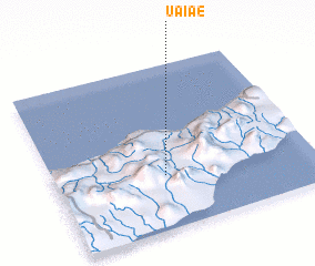 Places with similar names to Uaiae, East Timor ::
Disclaimer :: Information on this page comes without warranty of any kind |
||
|
Where is Uaiae? Elevation and coordinates ::
Latitude (lat): 8°40'18"S Longitude (lon): 126°25'25"E
Elevation (approx.): 604m (map arrows pan, magnifying glasses zoom) |
||
|
Visiting Uaiae? Hotel/Accommodation ::
Book a hotel in Uaiae Travel Guide ::
Buy a travel guide for East Timor rental cars ::
car rental offers GPS waypoint ::
download a GPX waypoint (PoI) of Uaiae for your GPS receiver
|
||