|
search place name
|
||
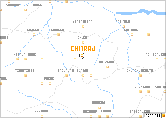
Chitraj (Quiché, Guatemala)Chitraj is a town in the Quiché region of Guatemala. An overview map of the region around Chitraj is displayed below.
regional and 3d topo map of Chitraj, Guatemala ::
Chitraj airports ::
The nearest airport is CBV - Coban, located 57.5 km north east of Chitraj.
Other airports nearby include GUA - Guatemala City La Aurora (65.9 km south east), TAP - Tapachula Intl (172.6 km west), SAL - San Salvador El Salvador Intl (264.2 km south east), Nearby towns ::
Turbalá (1.8km west) //
Chucá (3.7km north) //
Tunajá (3.7km south) //
Cruz Chich (4.1km south east) //
Zacualpa (5.2km south west) //
Patzijom (5.7km east) //
Sajcap (7.4km north) //
Yerbabuena (7.4km north) //
Canillá (7.7km north west) //
Pacoc (9.1km south west) //
[all distances 'as the bird flies' and approximate]  Places with similar names to Chitraj, Guatemala ::
// Shadow Ridge II (US)
// Shady Ridge (US)
// Chateau Ridge (US)
// Chata Ārāji (BD)
// Chuatroj (GT)
// Chadoragi (KP)
// Château-Rouge (FR)
Disclaimer :: Information on this page comes without warranty of any kind |
||
|
Where is Chitraj? Elevation and coordinates ::
Latitude (lat): 15°7'0"N Longitude (lon): 90°48'0"W
Elevation (approx.): 2319m (map arrows pan, magnifying glasses zoom) |
||
|
Visiting Chitraj? Hotel/Accommodation ::
Book a hotel in Chitraj Travel Guide ::
Buy a travel guide for Guatemala rental cars ::
car rental offers GPS waypoint ::
download a GPX waypoint (PoI) of Chitraj for your GPS receiver
|
||